
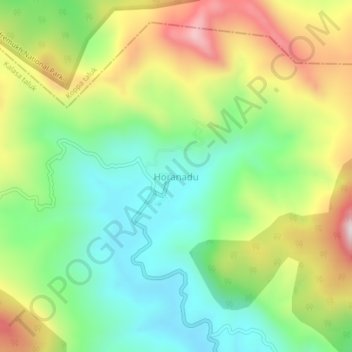
Horanadu topographic map
Interactive map
Click on the map to display elevation.
About this map
Name: Horanadu topographic map, elevation, terrain.
Average elevation: 3,353 ft
Minimum elevation: 2,497 ft
Maximum elevation: 4,692 ft
Hornadu, also known as Horanadu, is a Hindu holy locale and also a jain holy center Panchayat village located in kalasa taluk of Chikkamagaluru district, Karnataka, India. The deity at the Annapoorneshwari Temple at Hornadu is Annapurneshwari. The main deity of the goddess was put in place by Adi Shankaracharya; the new deity of goddess Annapurneshwari was consecrated in the temple in 1973. Horanadu has an elevation of 831 m (2,726 ft)
Other topographic maps
Click on a map to view its topography, its elevation and its terrain.
Kudremukha
India > Karnataka > Kalasa taluk
Kudremukha, Kalasa taluk, Chikkamagaluru District, Karnataka, India
Average elevation: 2,815 ft
Kalasa
India > Karnataka > Kalasa taluk
Kalasa, Kalasa taluk, Chikkamagaluru District, Karnataka, 577124, India
Average elevation: 2,943 ft