Geolocate

Fox Den topographic map

Click on the map to display elevation.

About this map

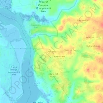
Name: Fox Den topographic map, elevation, terrain.

Location: Fox Den, Calvert County, Maryland, United States (38.59595 -76.68191 38.63595 -76.64191)

Average elevation: 59 ft

Minimum elevation: -10 ft

Maximum elevation: 157 ft

Other topographic maps

Click on a map to view its topography, its elevation and its terrain.

Lusby

United States > Maryland > Calvert County > Lusby

Average elevation: 62 ft

Huntingtown

United States > Maryland > Calvert County

Average elevation: 105 ft

Solomons

United States > Maryland > Calvert County > Solomons

Average elevation: 13 ft

Owings

United States > Maryland > Calvert County > Owings

Average elevation: 115 ft

Huntingtown

United States > Maryland > Calvert County

Average elevation: 105 ft

Calvert Cliffs

United States > Maryland > Calvert County

Average elevation: 36 ft

Gear up for your next adventure:

🧤Hiking Gloves - Protective gloves for rugged trails
📦Gear Storage Bags - Organize and protect outdoor equipment
☀️Outdoor Sunscreen - High protection sunscreen for outdoor activities
Solar GPS Watches - Advanced multisport watches with built-in topographic maps
🛶Inflatable Kayak - Portable kayak for rivers, lakes, and expeditions

As an Amazon Associate, this site earns from qualifying purchases at no extra cost to you.