
Make a donation
Gear up for your next adventure:
As an Amazon Associate, this site earns from qualifying purchases at no extra cost to you.
Ryazan topographic map
Click on the map to display elevation.
Make a donation
Gear up for your next adventure:
As an Amazon Associate, this site earns from qualifying purchases at no extra cost to you.
About this map
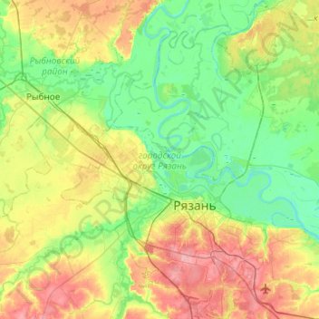
Name: Ryazan topographic map, elevation, terrain.
Location: Ryazan, Ryazan Oblast, Central Federal District, Russia (54.52826 39.53667 54.81201 39.89958)
Average elevation: 394 ft
Minimum elevation: 282 ft
Maximum elevation: 607 ft
Make a donation
Gear up for your next adventure:
As an Amazon Associate, this site earns from qualifying purchases at no extra cost to you.
Other topographic maps
Click on a map to view its topography, its elevation and its terrain.
Святой источник во имя вмц. Параскевы Пятницы на Толпино
Russia > Ryazan Oblast > Korablinsky District > Neznanovo
Average elevation: 384 ft
Make a donation
Gear up for your next adventure:
As an Amazon Associate, this site earns from qualifying purchases at no extra cost to you.