
Swarthmore topographic map
Click on the map to display elevation.
About this map
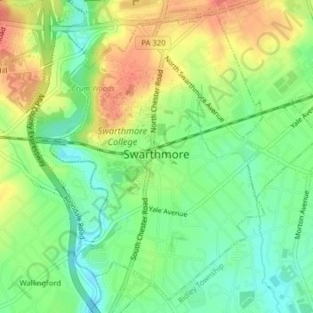
Name: Swarthmore topographic map, elevation, terrain.
Average elevation: 144 ft
Minimum elevation: 59 ft
Maximum elevation: 246 ft
Delaware County trails, hiking, mountain biking, running and outdoor activities
Other topographic maps
Click on a map to view its topography, its elevation and its terrain.
Springfield
United States > Pennsylvania > Delaware County > Springfield Township > Springfield
Average elevation: 190 ft
Glen Riddle
United States > Pennsylvania > Delaware County > Middletown Township
Average elevation: 226 ft
Saint Davids
United States > Pennsylvania > Delaware County > Radnor Township
Average elevation: 400 ft
Crum Creek Manor
United States > Pennsylvania > Delaware County > Nether Providence Township
Average elevation: 125 ft
Thornton
United States > Pennsylvania > Delaware County > Thornbury Township
Average elevation: 397 ft
Merwood Park
United States > Pennsylvania > Delaware County > Haverford Township > Coreze
Average elevation: 325 ft
Ardmore Park
United States > Pennsylvania > Delaware County > Haverford Township
Average elevation: 312 ft
South Media
United States > Pennsylvania > Delaware County > Nether Providence Township
Average elevation: 213 ft
Dilworthtown
United States > Pennsylvania > Delaware County > Chadds Ford Township
Average elevation: 400 ft
Johnsons Corner
United States > Pennsylvania > Delaware County > Concord Township
Average elevation: 381 ft
Pilgrim Gardens
United States > Pennsylvania > Delaware County > Haverford Township
Average elevation: 249 ft