
Bramshaw topographic map
Click on the map to display elevation.
About this map
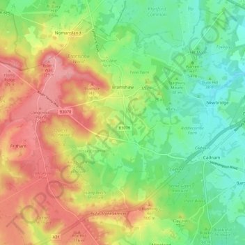
Name: Bramshaw topographic map, elevation, terrain.
Location: Bramshaw, New Forest, Hampshire, England, United Kingdom (50.90277 -1.69643 50.95925 -1.59009)
Average elevation: 217 ft
Minimum elevation: 49 ft
Maximum elevation: 436 ft
Other topographic maps
Click on a map to view its topography, its elevation and its terrain.
South Baddesley
United Kingdom > England > Hampshire > New Forest > Norleywood
Average elevation: 43 ft
Warwick Slade
United Kingdom > England > Hampshire > New Forest > Lyndhurst > Allum Green
Average elevation: 118 ft
London Minstead
United Kingdom > England > Hampshire > New Forest > Minstead
Average elevation: 180 ft
Newbridge Inclosure
United Kingdom > England > Hampshire > New Forest > Copythorne
Average elevation: 95 ft
Bickton
United Kingdom > England > Hampshire > New Forest > Fordingbridge > Bickton
Average elevation: 128 ft
Monkton Mead
United Kingdom > England > Hampshire > New Forest > Breamore > South Charford
Average elevation: 171 ft