Geolocate

Gene Autry topographic map

Click on the map to display elevation.

About this map
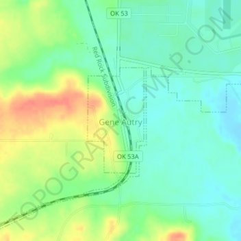
Name: Gene Autry topographic map, elevation, terrain.

Location: Gene Autry, Carter County, Oklahoma, 73436, United States (34.27793 -97.04257 34.28978 -97.03490)

Average elevation: 758 ft

Minimum elevation: 696 ft

Maximum elevation: 856 ft

Carter County trails, hiking, mountain biking, running and outdoor activities

Other topographic maps

Click on a map to view its topography, its elevation and its terrain.
Glenn

United States > Oklahoma > Carter County

Average elevation: 876 ft

Provence

United States > Oklahoma > Carter County

Average elevation: 863 ft

Gear up for your next adventure:

🪶Fire Starter Kit - Reliable fire starter for survival and camping
🪶Multi‑Purpose Knife - Useful blade for camp and trail
🌡️Handheld Weather Meters - Measure wind, temp, and pressure for safe mountain travel
🔭Stargazing Telescopes - Perfect for camping in low-light pollution areas shown on maps
🩳Quick‑Dry Hiking Shorts - Comfortable and quick‑dry shorts for summer hiking

As an Amazon Associate, this site earns from qualifying purchases at no extra cost to you.