Geolocate

Cenchat topographic map

Click on the map to display elevation.

About this map

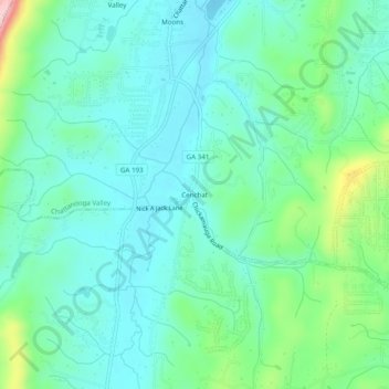
Name: Cenchat topographic map, elevation, terrain.

Location: Cenchat, Walker County, Georgia, 30725, United States (34.89285 -85.36579 34.93285 -85.32579)

Average elevation: 843 ft

Minimum elevation: 663 ft

Maximum elevation: 1,460 ft

Walker County trails, hiking, mountain biking, running and outdoor activities

Other topographic maps

Click on a map to view its topography, its elevation and its terrain.

Lookout Mountain

United States > Georgia > Walker County

Average elevation: 1,332 ft

Chattanooga Valley

United States > Georgia > Walker County

Average elevation: 906 ft

Rock Spring

United States > Georgia > Walker County

Average elevation: 863 ft

Fairview

United States > Georgia > Walker County

Average elevation: 863 ft

Missionary Ridge

United States > Georgia > Walker County

Average elevation: 1,106 ft

Gear up for your next adventure:

🖼️Topo Map Wall Art - Decorative topographic prints of famous peaks and regions
👖Convertible Hiking Pants - Versatile zip-off pants for changing altitudes and temperatures
🔋Rechargeable Batteries - Power up your outdoor devices
🎒Trekking Poles - Sturdy poles for balance and stability on rough terrain
👓Polarized Sunglasses - Outdoor sunglasses for glare reduction

As an Amazon Associate, this site earns from qualifying purchases at no extra cost to you.