Geolocate

Missionary Ridge topographic map

Click on the map to display elevation.

About this map

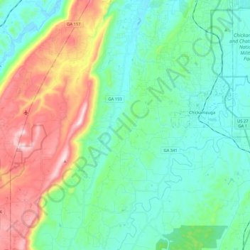
Name: Missionary Ridge topographic map, elevation, terrain.

Location: Missionary Ridge, Walker County, Georgia, United States (34.77662 -85.38727 34.94796 -85.29797)

Average elevation: 1,106 ft

Minimum elevation: 653 ft

Maximum elevation: 2,287 ft

Walker County trails, hiking, mountain biking, running and outdoor activities

Other topographic maps

Click on a map to view its topography, its elevation and its terrain.

Chattanooga Valley

United States > Georgia > Walker County

Average elevation: 906 ft

Marsh Crossing

United States > Georgia > Walker County

Average elevation: 1,024 ft

Rock Spring

United States > Georgia > Walker County

Average elevation: 863 ft

Lookout Mountain

United States > Georgia > Walker County

Average elevation: 1,332 ft

Rock Spring

United States > Georgia > Walker County

Average elevation: 853 ft

Cenchat

United States > Georgia > Walker County

Average elevation: 843 ft

Fairview

United States > Georgia > Walker County

Average elevation: 863 ft

Yates Lake

United States > Georgia > Walker County

Average elevation: 1,168 ft

Walnut Grove

United States > Georgia > Walker County

Average elevation: 823 ft

Flintstone

United States > Georgia > Walker County

Average elevation: 846 ft

White Oak

United States > Georgia > Walker County > White Oak

Average elevation: 817 ft

Gear up for your next adventure:

🪶Paracord Bracelet - Survival bracelet with built‑in tools
🔌USB Car Charger - Car charger for on‑the‑go power needs
🔥Fast-Boil Camping Stoves - Efficient cooking systems for quick trail meals
🦶Carbon Trekking Poles - Reduce knee impact on steep descents with ultra-light poles
❄️Traction Cleats - Prevent slips on icy trails during winter hikes

As an Amazon Associate, this site earns from qualifying purchases at no extra cost to you.