
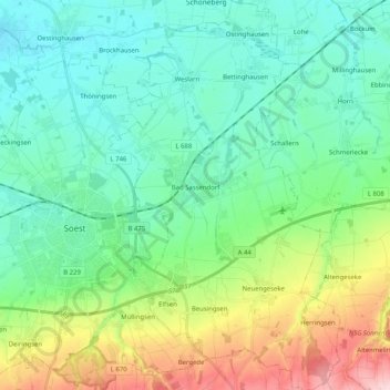
Bad Sassendorf topographic map
Interactive map
Click on the map to display elevation.
About this map
Name: Bad Sassendorf topographic map, elevation, terrain.
Average elevation: 410 ft
Minimum elevation: 223 ft
Maximum elevation: 942 ft
Other topographic maps
Click on a map to view its topography, its elevation and its terrain.
Wickede (Ruhr)
Duitsland > Noordrijn-Westfalen > Kreis Soest
Wickede (Ruhr), Kreis Soest, Noordrijn-Westfalen, 58739, Duitsland
Average elevation: 581 ft
Soest
Duitsland > Noordrijn-Westfalen > Kreis Soest
Soest, Kreis Soest, Noordrijn-Westfalen, 59494, Duitsland
Average elevation: 397 ft
Welver
Duitsland > Noordrijn-Westfalen > Kreis Soest
Welver, Kreis Soest, Noordrijn-Westfalen, 59514, Duitsland
Average elevation: 256 ft
Oestereiden
Duitsland > Noordrijn-Westfalen > Kreis Soest
Oestereiden, Rüthen, Kreis Soest, Noordrijn-Westfalen, Duitsland
Average elevation: 755 ft
Hamorsbruch
Duitsland > Noordrijn-Westfalen > Kreis Soest > Warstein
Hamorsbruch, Warstein-Ortschaft, Warstein, Kreis Soest, Noordrijn-Westfalen, 59581, Duitsland
Average elevation: 1,657 ft
Lippeaue
Duitsland > Noordrijn-Westfalen > Kreis Soest > Lippetal
Lippeaue, Lippetal, Kreis Soest, Noordrijn-Westfalen, Duitsland
Average elevation: 331 ft
Warstein
Duitsland > Noordrijn-Westfalen > Kreis Soest
Warstein, Kreis Soest, Noordrijn-Westfalen, 59581, Duitsland
Average elevation: 1,224 ft
Werl
Duitsland > Noordrijn-Westfalen > Kreis Soest > Werl
Werl, Kreis Soest, Noordrijn-Westfalen, 59457, Duitsland
Average elevation: 400 ft