Geolocate

Salen topographic map

Click on the map to display elevation.

About this map

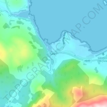
Name: Salen topographic map, elevation, terrain.

Location: Salen, Argyll and Bute, Scotland, PA72 6JQ, United Kingdom (56.49678 -5.96749 56.53678 -5.92749)

Average elevation: 177 ft

Minimum elevation: 0 ft

Maximum elevation: 1,037 ft

Other topographic maps

Click on a map to view its topography, its elevation and its terrain.

Tarbert

United Kingdom > Scotland > Argyll and Bute

Average elevation: 226 ft

Easdale

United Kingdom > Scotland > Argyll and Bute > Easdale

Average elevation: 26 ft

Torsa

United Kingdom > Scotland > Argyll and Bute > Cuan > Silver Moon

Average elevation: 39 ft

Texa

United Kingdom > Scotland > Argyll and Bute

Average elevation: 3 ft

Bute

United Kingdom > Scotland > Argyll and Bute > Townhead

Average elevation: 135 ft

Scarba

United Kingdom > Scotland > Argyll and Bute

Average elevation: 299 ft

Coll

United Kingdom > Scotland > Argyll and Bute > Arinagour

Average elevation: 23 ft

Ardrishaig

United Kingdom > Scotland > Argyll and Bute

Average elevation: 217 ft

Gear up for your next adventure:

📱Heavy-Duty Phone Cases - Drop-proof and waterproof protection for outdoor navigation
🔥Fast-Boil Camping Stoves - Efficient cooking systems for quick trail meals
🧣Hiking Neck Gaiter - Multi‑use neck protection for outdoor weather
🔦Powerful Headlamps - Ultra-bright hands-free lighting for night navigation
🚁Photography Drones - Capture stunning aerial views of landforms and topography

As an Amazon Associate, this site earns from qualifying purchases at no extra cost to you.