Geolocate

Griebal topographic map

Click on the map to display elevation.

About this map
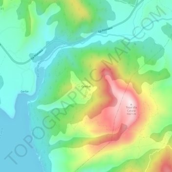
Name: Griebal topographic map, elevation, terrain.

Location: Griebal, Aínsa-Sobrarbe/L'Aínsa-Sobrarbe, Sobrarbe, Huesca, Aragon, 22337, Spain (42.36465 0.18305 42.40465 0.22305)

Average elevation: 2,182 ft

Minimum elevation: 1,660 ft

Maximum elevation: 3,310 ft

Other topographic maps

Click on a map to view its topography, its elevation and its terrain.
Boltaña

Spain > Aragon > Sobrarbe

Average elevation: 2,822 ft

Gear up for your next adventure:

🏕️Family Camping Gear - Essentials for group camping trips
🛰️Handheld GPS Units - Professional satellite navigators for precise backcountry mapping
🗻Climbing Gear Basics - Essential gear for beginner climbers
🔌USB Car Charger - Car charger for on‑the‑go power needs
🪓Survival Multi‑Tool - Versatile tool for camp and trail tasks

As an Amazon Associate, this site earns from qualifying purchases at no extra cost to you.