Geolocate

Lake Clear topographic map

Click on the map to display elevation.

About this map

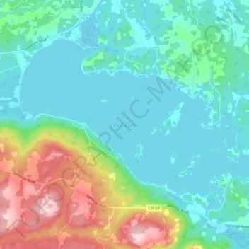
Name: Lake Clear topographic map, elevation, terrain.

Location: Lake Clear, Bonnechere Valley, Renfrew County, Eastern Ontario, Ontario, Canada (45.41530 -77.24292 45.46451 -77.14124)

Average elevation: 955 ft

Minimum elevation: 745 ft

Maximum elevation: 1,581 ft

Other topographic maps

Click on a map to view its topography, its elevation and its terrain.

Foymount

Canada > Ontario > Renfrew County > Bonnechere Valley

The location is also popular for amateur astronomers given the high altitude and low levels of artificial light.

Average elevation: 1,417 ft

Eganville

Canada > Ontario > Renfrew County > Bonnechere Valley

Average elevation: 610 ft

Sheedy Lake

Canada > Ontario > Renfrew County > Bonnechere Valley

Average elevation: 1,204 ft

Roche Lake

Canada > Ontario > Renfrew County > Bonnechere Valley

Average elevation: 843 ft

Eganville

Canada > Ontario > Renfrew County > Bonnechere Valley

Average elevation: 610 ft

Gear up for your next adventure:

📚USA Hiking Guide Books - Top trail guides and map books
🧭Compass with Lanyard - Easy‑carry compass for navigation
🩳Quick‑Dry Hiking Shorts - Comfortable and quick‑dry shorts for summer hiking
👟Trail Running Shoes - Lightweight shoes for trail runners
🛠️Outdoor Gear Repair Kit - Essential tools to fix gear on the trail

As an Amazon Associate, this site earns from qualifying purchases at no extra cost to you.