Geolocate

Patterson topographic map

Click on the map to display elevation.

About this map

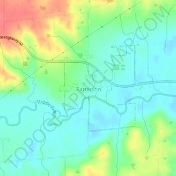
Name: Patterson topographic map, elevation, terrain.

Location: Patterson, Madison County, Iowa, 50218, United States (41.34192 -93.88623 41.35510 -93.87085)

Average elevation: 928 ft

Minimum elevation: 856 ft

Maximum elevation: 1,073 ft

Madison County trails, hiking, mountain biking, running and outdoor activities

Other topographic maps

Click on a map to view its topography, its elevation and its terrain.

Patterson

United States > Iowa > Madison County > Patterson > Patterson

Average elevation: 945 ft

Gear up for your next adventure:

🔥Camping Stove - Portable stove for camping and backcountry cooking
🌡️Portable Weather Meter - Track weather conditions on the trail
🔋Solar Power Banks - Keep your GPS and phone charged in remote wilderness areas
🎒Gear Packing Cubes - Organize your backpack efficiently
🪶Survival Guide Book - Expert advice for emergency preparedness

As an Amazon Associate, this site earns from qualifying purchases at no extra cost to you.