
Make a donation
Gear up for your next adventure:
As an Amazon Associate, this site earns from qualifying purchases at no extra cost to you.
Plaaz topographic map
Click on the map to display elevation.
Make a donation
Gear up for your next adventure:
As an Amazon Associate, this site earns from qualifying purchases at no extra cost to you.
About this map
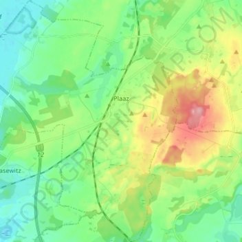
Name: Plaaz topographic map, elevation, terrain.
Average elevation: 154 ft
Minimum elevation: 30 ft
Maximum elevation: 417 ft
Make a donation
Gear up for your next adventure:
As an Amazon Associate, this site earns from qualifying purchases at no extra cost to you.
Other topographic maps
Click on a map to view its topography, its elevation and its terrain.
Wischuer
Deutschland > Mecklenburg-Vorpommern > Landkreis Rostock > Biendorf
Average elevation: 167 ft
Make a donation
Gear up for your next adventure:
As an Amazon Associate, this site earns from qualifying purchases at no extra cost to you.
Teßmannsdorf
Deutschland > Mecklenburg-Vorpommern > Landkreis Rostock > Am Salzhaff
Average elevation: 23 ft
Miekenhagen
Deutschland > Mecklenburg-Vorpommern > Landkreis Rostock > Radegast
Average elevation: 223 ft
Nienhagen
Deutschland > Mecklenburg-Vorpommern > Landkreis Rostock > Groß Wokern
Average elevation: 243 ft
Make a donation
Gear up for your next adventure:
As an Amazon Associate, this site earns from qualifying purchases at no extra cost to you.
Questin
Deutschland > Mecklenburg-Vorpommern > Landkreis Rostock > Alt Bukow
Average elevation: 125 ft
Pepelow
Deutschland > Mecklenburg-Vorpommern > Landkreis Rostock > Am Salzhaff
Average elevation: 52 ft
Make a donation
Gear up for your next adventure:
As an Amazon Associate, this site earns from qualifying purchases at no extra cost to you.
Bad Doberan
Deutschland > Mecklenburg-Vorpommern > Landkreis Rostock > Bad Doberan > Bad Doberan
Die Farben der Stadt Bad Doberan sind Gold und Blau. Die Flagge der Stadt Bad Doberan ist gleichmäßig längsgestreift von Blau, Weiß und Rot. Die Höhe des Flaggentuches verhält sich zur Länge wie 3 zu 5.
Average elevation: 95 ft
Güstrow
Deutschland > Mecklenburg-Vorpommern > Landkreis Rostock > Güstrow > Güstrow
Average elevation: 52 ft
Görzhausen
Deutschland > Mecklenburg-Vorpommern > Landkreis Rostock > Hohen Demzin
Average elevation: 220 ft
Bützow
Deutschland > Mecklenburg-Vorpommern > Landkreis Rostock > Bützow > Bützow
Average elevation: 36 ft
Make a donation
Gear up for your next adventure:
As an Amazon Associate, this site earns from qualifying purchases at no extra cost to you.
Neu Heinde
Deutschland > Mecklenburg-Vorpommern > Landkreis Rostock > Prebberede
Average elevation: 154 ft
Make a donation
Gear up for your next adventure:
As an Amazon Associate, this site earns from qualifying purchases at no extra cost to you.
Die Vierzehner
Deutschland > Mecklenburg-Vorpommern > Landkreis Rostock > Wardow
Average elevation: 131 ft
Voßbarg
Deutschland > Mecklenburg-Vorpommern > Landkreis Rostock > Alt Sührkow
Average elevation: 217 ft
Make a donation
Gear up for your next adventure:
As an Amazon Associate, this site earns from qualifying purchases at no extra cost to you.
Berghausen
Deutschland > Mecklenburg-Vorpommern > Landkreis Rostock > Biendorf
Average elevation: 89 ft
Badenberg
Deutschland > Mecklenburg-Vorpommern > Landkreis Rostock > Groß Wokern > Nienhagen
Average elevation: 236 ft
Suckwitz
Deutschland > Mecklenburg-Vorpommern > Landkreis Rostock > Reimershagen
Average elevation: 184 ft
Dersentin
Deutschland > Mecklenburg-Vorpommern > Landkreis Rostock > Lalendorf
Average elevation: 184 ft
Make a donation
Gear up for your next adventure:
As an Amazon Associate, this site earns from qualifying purchases at no extra cost to you.
Groß Lüsewitz
Deutschland > Mecklenburg-Vorpommern > Landkreis Rostock > Sanitz
Average elevation: 125 ft
Kurzen Trechow
Deutschland > Mecklenburg-Vorpommern > Landkreis Rostock > Bernitt
Average elevation: 151 ft
Make a donation
Gear up for your next adventure:
As an Amazon Associate, this site earns from qualifying purchases at no extra cost to you.
Make a donation
Gear up for your next adventure:
As an Amazon Associate, this site earns from qualifying purchases at no extra cost to you.
Karstorf
Deutschland > Mecklenburg-Vorpommern > Landkreis Rostock > Hohen Demzin
Average elevation: 164 ft
Ikendorf
Deutschland > Mecklenburg-Vorpommern > Landkreis Rostock > Broderstorf
Average elevation: 141 ft
Neu Teschow
Deutschland > Mecklenburg-Vorpommern > Landkreis Rostock > Alt Bukow
Average elevation: 154 ft
Make a donation
Gear up for your next adventure:
As an Amazon Associate, this site earns from qualifying purchases at no extra cost to you.
Küche
Deutschland > Mecklenburg-Vorpommern > Landkreis Rostock > Krakow am See
Average elevation: 174 ft
Wichmannsberg
Deutschland > Mecklenburg-Vorpommern > Landkreis Rostock > Baumgarten
Average elevation: 69 ft
Make a donation
Gear up for your next adventure:
As an Amazon Associate, this site earns from qualifying purchases at no extra cost to you.
Klein Bölkow
Deutschland > Mecklenburg-Vorpommern > Landkreis Rostock > Satow
Average elevation: 108 ft
Wesselstorf
Deutschland > Mecklenburg-Vorpommern > Landkreis Rostock > Selpin
Average elevation: 115 ft
Make a donation
Gear up for your next adventure:
As an Amazon Associate, this site earns from qualifying purchases at no extra cost to you.
Perow
Deutschland > Mecklenburg-Vorpommern > Landkreis Rostock > Groß Wüstenfelde
Average elevation: 118 ft
Klein Bollhagen
Deutschland > Mecklenburg-Vorpommern > Landkreis Rostock > Wittenbeck
Average elevation: 56 ft
Bargeshagen
Deutschland > Mecklenburg-Vorpommern > Landkreis Rostock > Admannshagen-Bargeshagen
Average elevation: 30 ft
Make a donation
Gear up for your next adventure:
As an Amazon Associate, this site earns from qualifying purchases at no extra cost to you.
Groß Upahl
Deutschland > Mecklenburg-Vorpommern > Landkreis Rostock > Gülzow-Prüzen
Average elevation: 171 ft
Remlin
Deutschland > Mecklenburg-Vorpommern > Landkreis Rostock > Schwasdorf > Remlin
Average elevation: 121 ft
Pinnenberg
Deutschland > Mecklenburg-Vorpommern > Landkreis Rostock > Hohenfelde
Average elevation: 210 ft
Make a donation
Gear up for your next adventure:
As an Amazon Associate, this site earns from qualifying purchases at no extra cost to you.
Jennewitz
Deutschland > Mecklenburg-Vorpommern > Landkreis Rostock > Kröpelin
Average elevation: 256 ft
Behnkenhagen
Deutschland > Mecklenburg-Vorpommern > Landkreis Rostock > Behnkenhagen
Average elevation: 69 ft
Neu Karin
Deutschland > Mecklenburg-Vorpommern > Landkreis Rostock > Neu Karin
Average elevation: 203 ft
Make a donation
Gear up for your next adventure:
As an Amazon Associate, this site earns from qualifying purchases at no extra cost to you.
Lohmen
Deutschland > Mecklenburg-Vorpommern > Landkreis Rostock > Lohmen > Lohmen
Die Kirche mag Mitte des 13. Jahrhunderts schon im Bau gewesen sein. Seit 1234 war sie Patronatskirche des Dobbertiner Klosters. Als rechteckiger Feldsteinbau, bestehend aus Chor, Schiff und Turm, wurde sie in mehreren Bauphasen errichtet. Der Chor mit seiner geraden Ostwand wurde als erster Bauteil…
Average elevation: 161 ft
Vogtshagen
Deutschland > Mecklenburg-Vorpommern > Landkreis Rostock > Poppendorf > Vogtshagen
Average elevation: 108 ft
Tessin
Deutschland > Mecklenburg-Vorpommern > Landkreis Rostock > Tessin > Tessin
Average elevation: 102 ft
Make a donation
Gear up for your next adventure:
As an Amazon Associate, this site earns from qualifying purchases at no extra cost to you.
Cordshagen
Deutschland > Mecklenburg-Vorpommern > Landkreis Rostock > Blankenhagen > Cordshagen
Average elevation: 151 ft
Buchholz
Deutschland > Mecklenburg-Vorpommern > Landkreis Rostock > Ziesendorf > Buchholz
Average elevation: 112 ft
Bellin
Deutschland > Mecklenburg-Vorpommern > Landkreis Rostock > Krakow am See > Bellin
Beschreibung: „Die Flagge der Gemeinde ist quer zur Längsachse des Flaggentuchs von Rot, Weiß und Rot gestreift. Die roten Streifen nehmen je ein Viertel, der weiße Streifen nimmt die Hälfte der Länge des Flaggentuchs ein. In der Mitte des weißen Streifens liegt das Gemeindewappen, das zwei Drittel der…
Average elevation: 171 ft
Make a donation
Gear up for your next adventure:
As an Amazon Associate, this site earns from qualifying purchases at no extra cost to you.
Schwarzer See
Deutschland > Mecklenburg-Vorpommern > Landkreis Rostock > Teterow
Average elevation: 102 ft
Michelwiese
Deutschland > Mecklenburg-Vorpommern > Landkreis Rostock > Dahmen > Barz
Average elevation: 180 ft
Make a donation
Gear up for your next adventure:
As an Amazon Associate, this site earns from qualifying purchases at no extra cost to you.
Westenbrügge
Deutschland > Mecklenburg-Vorpommern > Landkreis Rostock > Biendorf
Average elevation: 98 ft
Make a donation
Gear up for your next adventure:
As an Amazon Associate, this site earns from qualifying purchases at no extra cost to you.