
Piseco topographic map
Click on the map to display elevation.
About this map
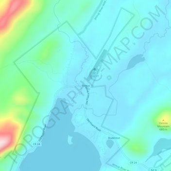
Name: Piseco topographic map, elevation, terrain.
Average elevation: 1,798 ft
Minimum elevation: 1,650 ft
Maximum elevation: 2,667 ft
Hamilton County trails, hiking, mountain biking, running and outdoor activities
Other topographic maps
Click on a map to view its topography, its elevation and its terrain.
Town of Long Lake
United States > New York > Hamilton County
Long Lake is located in northern Hamilton County at 43°58′18″N 074°35′10″W / 43.97167°N 74.58611°W / 43.97167; -74.58611 (43.9717408, -74.5862453) and its elevation is 1,906 feet (581 m). It is bordered to the west by Herkimer County, to the north by St. Lawrence and Franklin counties, and…
Average elevation: 1,985 ft
Village of Speculator
United States > New York > Hamilton County > Town of Lake Pleasant
Speculator Mountain, with an altitude of 2,966 feet (904 m), is south of the village.
Average elevation: 2,126 ft
Handsome Pond
United States > New York > Hamilton County > Town of Long Lake
Average elevation: 1,926 ft
Lower Brown Tract Pond
United States > New York > Hamilton County > Town of Inlet
Average elevation: 1,847 ft
Town of Indian Lake
United States > New York > Hamilton County
Indian Lake has a humid continental climate (Dfb), although it is much colder than most of New York due to its high elevation and northern location. Winters are cold and snowy, while summers are warm and humid. Precipitation is abundant year round, but peaks in summer. The coldest month is January, with a mean…
Average elevation: 2,051 ft
Big Bad Luck Pond
United States > New York > Hamilton County > Town of Indian Lake
Average elevation: 1,768 ft
Town of Long Lake
United States > New York > Hamilton County
Long Lake is located in northern Hamilton County at 43°58′18″N 074°35′10″W / 43.97167°N 74.58611°W / 43.97167; -74.58611 (43.9717408, -74.5862453) and its elevation is 1,906 feet (581 m). It is bordered to the west by Herkimer County, to the north by St. Lawrence and Franklin counties, and…
Average elevation: 1,985 ft
Village of Speculator
United States > New York > Hamilton County > Town of Lake Pleasant
Speculator Mountain, with an altitude of 2,966 feet (904 m), is south of the village.
Average elevation: 2,126 ft
Town of Indian Lake
United States > New York > Hamilton County
Indian Lake has a humid continental climate (Dfb), although it is much colder than most of New York due to its high elevation and northern location. Winters are cold and snowy, while summers are warm and humid. Precipitation is abundant year round, but peaks in summer. The coldest month is January, with a mean…
Average elevation: 2,051 ft