
Make a donation
Gear up for your next adventure:
As an Amazon Associate, this site earns from qualifying purchases at no extra cost to you.
Jefferson topographic map
Click on the map to display elevation.
Make a donation
Gear up for your next adventure:
As an Amazon Associate, this site earns from qualifying purchases at no extra cost to you.
About this map
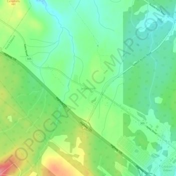
Name: Jefferson topographic map, elevation, terrain.
Average elevation: 112 ft
Minimum elevation: 0 ft
Maximum elevation: 318 ft
Make a donation
Gear up for your next adventure:
As an Amazon Associate, this site earns from qualifying purchases at no extra cost to you.
Other topographic maps
Click on a map to view its topography, its elevation and its terrain.
Margaret Boone Memorial Park
Canada > Nova Scotia > Cape Breton Regional Municipality > Dominion
Average elevation: 43 ft
Make a donation
Gear up for your next adventure:
As an Amazon Associate, this site earns from qualifying purchases at no extra cost to you.
Cary Rocks Cove
Canada > Nova Scotia > Cape Breton Regional Municipality > Main-à-Dieu
Average elevation: 10 ft
Make a donation
Gear up for your next adventure:
As an Amazon Associate, this site earns from qualifying purchases at no extra cost to you.
Glace Bay
Canada > Nova Scotia > Cape Breton Regional Municipality > Glace Bay
Average elevation: 49 ft