
Make a donation
Gear up for your next adventure:
As an Amazon Associate, this site earns from qualifying purchases at no extra cost to you.
Stanley Park topographic map
Click on the map to display elevation.
Make a donation
Gear up for your next adventure:
As an Amazon Associate, this site earns from qualifying purchases at no extra cost to you.
About this map
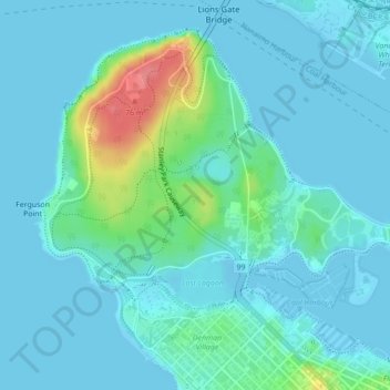
Name: Stanley Park topographic map, elevation, terrain.
Average elevation: 46 ft
Minimum elevation: -16 ft
Maximum elevation: 276 ft
Make a donation
Gear up for your next adventure:
As an Amazon Associate, this site earns from qualifying purchases at no extra cost to you.
Other topographic maps
Click on a map to view its topography, its elevation and its terrain.
Victoria-Fraserview
Canada > British Columbia > Metro Vancouver Regional District > Vancouver
Average elevation: 220 ft
English Bay
Canada > British Columbia > Metro Vancouver Regional District > Vancouver
Average elevation: 23 ft
Marpole
Canada > British Columbia > Metro Vancouver Regional District > Vancouver
Average elevation: 92 ft
Vancouver East
Canada > British Columbia > Metro Vancouver Regional District > Vancouver
Average elevation: 82 ft
Make a donation
Gear up for your next adventure:
As an Amazon Associate, this site earns from qualifying purchases at no extra cost to you.
Renfrew-Collingwood
Canada > British Columbia > Metro Vancouver Regional District > Vancouver
Average elevation: 236 ft
Cypress Pond
Canada > British Columbia > Metro Vancouver Regional District > Vancouver
Average elevation: 282 ft
Little Mountain
Canada > British Columbia > Metro Vancouver Regional District > Vancouver
Little Mountain, elevation 125 m (410 ft), is a mountain in the central part of the city of Vancouver, British Columbia, Canada. The mountain is home to Queen Elizabeth Park, which sits at the top of the mountain, and Nat Bailey Stadium, which is located near the base. The mountain lends its name to the Riley…
Average elevation: 266 ft
Riley Park
Canada > British Columbia > Metro Vancouver Regional District > Vancouver
Average elevation: 246 ft
Make a donation
Gear up for your next adventure:
As an Amazon Associate, this site earns from qualifying purchases at no extra cost to you.
Arbutus-Ridge
Canada > British Columbia > Metro Vancouver Regional District > Vancouver
Average elevation: 197 ft
Kitsilano 6
Canada > British Columbia > Metro Vancouver Regional District > Vancouver
Average elevation: 72 ft
Downtown
Canada > British Columbia > Metro Vancouver Regional District > Vancouver
Average elevation: 46 ft
Fairview
Canada > British Columbia > Metro Vancouver Regional District > Vancouver
Average elevation: 102 ft
Make a donation
Gear up for your next adventure:
As an Amazon Associate, this site earns from qualifying purchases at no extra cost to you.
West End
Canada > British Columbia > Metro Vancouver Regional District > Vancouver
Average elevation: 49 ft
False Creek
Canada > British Columbia > Metro Vancouver Regional District > Vancouver
Average elevation: 59 ft
Killarney
Canada > British Columbia > Metro Vancouver Regional District > Vancouver
Average elevation: 240 ft
Kerrisdale
Canada > British Columbia > Metro Vancouver Regional District > Vancouver
Average elevation: 128 ft
Make a donation
Gear up for your next adventure:
As an Amazon Associate, this site earns from qualifying purchases at no extra cost to you.
Kitsilano
Canada > British Columbia > Metro Vancouver Regional District > Vancouver
Average elevation: 79 ft
Dunbar-Southlands
Canada > British Columbia > Metro Vancouver Regional District > Vancouver
Average elevation: 141 ft
Granville Island
Canada > British Columbia > Metro Vancouver Regional District > Vancouver
Average elevation: 82 ft
Grandview-Woodland
Canada > British Columbia > Metro Vancouver Regional District > Vancouver
Average elevation: 92 ft
Make a donation
Gear up for your next adventure:
As an Amazon Associate, this site earns from qualifying purchases at no extra cost to you.
Kensington-Cedar Cottage
Canada > British Columbia > Metro Vancouver Regional District > Vancouver
Average elevation: 210 ft
Sunset
Canada > British Columbia > Metro Vancouver Regional District > Vancouver
Average elevation: 174 ft
Mount Pleasant
Canada > British Columbia > Metro Vancouver Regional District > Vancouver
Average elevation: 92 ft
Hastings-Sunrise
Canada > British Columbia > Metro Vancouver Regional District > Vancouver
Average elevation: 131 ft
Make a donation
Gear up for your next adventure:
As an Amazon Associate, this site earns from qualifying purchases at no extra cost to you.
Strathcona
Canada > British Columbia > Metro Vancouver Regional District > Vancouver
Average elevation: 33 ft
Kitsilano
Canada > British Columbia > Metro Vancouver Regional District > Vancouver
Average elevation: 79 ft
Fairview
Canada > British Columbia > Metro Vancouver Regional District > Vancouver
Average elevation: 102 ft