
Amhara Region topographic map
Interactive map
Click on the map to display elevation.
About this map
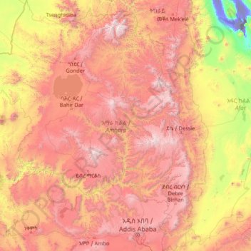
Name: Amhara Region topographic map, elevation, terrain.
Location: Amhara Region, Ethiopia (8.71589 35.26165 13.78090 40.21334)
Average elevation: 5,308 ft
Minimum elevation: -374 ft
Maximum elevation: 14,613 ft
The Amhara region has the most world heritage sites of any region in Ethiopia and is endowed with natural and geographic wonders and ecosystems. The region contains Ethiopia's largest inland body of water Lake Tana, which is the source of the Blue Nile river. In 2015 Lake Tana was recognized as a UNESCO Biosphere Reserve for its enormous biodiversity, and national and international importance. The Semien Mountains National Park has been designated as the one of the first natural World Heritage Site by UNESCO in the world, and the very first in Africa in the natural criteria since 1978. Chosen for its spectacular landscapes and global significance for biodiversity conservation. Situated within the Semien Mountains, Ethiopia's highest peaks Ras Dashen reaches an elevation of (4,543 m (14,905 ft)). The park also has Ethiopia's second and third highest mountains, Kidis Yared (4,453 m (14,610 ft)) and Mount Bwahit (4,437 m (14,557 ft)). The park is home to endangered species found nowhere else in the world, examples of endemic fauna include the iconic walia ibex, the gelada baboon, and the Ethiopian wolf (or Simien fox) among others. The wide range of altitudes has given the country a variety of ecologically distinct areas, leading to the evolution of endemic species in ecological isolation.
Other topographic maps
Click on a map to view its topography, its elevation and its terrain.
Dalota
Dalota, North Shewa (Amhara Region), Amhara Region, Ethiopia
Average elevation: 6,115 ft
Ambassador Park
Ethiopia > Addis Ababa > Arada > Addis Ababa
Ambassador Park, Posta Bet, Addis Ababa, Arada, Addis Ababa, Ethiopia
Average elevation: 7,795 ft
Durum
Ethiopia > Southern Nations, Nationalities, and Peoples
Durum, South Omo, Southern Nations, Nationalities, and Peoples, Ethiopia
Average elevation: 1,421 ft
Gorki
Gorki, South West Shewa, Oromia Region, Ethiopia
Average elevation: 7,110 ft
Wayu
Ethiopia > Oromia Region > Jimma Rare
Wayu, Jimma Rare, Horo Guduru, Oromia Region, Ethiopia
Average elevation: 7,602 ft
Dimtu
Ethiopia > Benishangul-Gumuz Region
Dimtu, Kemashi, Benishangul-Gumuz Region, Ethiopia
Average elevation: 3,606 ft
Danakil Depression
Danakil Depression, Zone 2, Afar Region, Ethiopia
Average elevation: -377 ft
Waliso
Waliso, South West Shewa, Oromia Region, Ethiopia
Average elevation: 6,706 ft
Mille
Ethiopia > Afar Region > Lower Miele
Mille, Lower Miele, Zone 1, Afar Region, Ethiopia
Average elevation: 1,627 ft
Addis Ababa
Ethiopia > Addis Ababa > Arada
Addis Ababa, Arada, Addis Ababa, 3578, Ethiopia
Average elevation: 8,258 ft
Welkite
Ethiopia > Southern Nations, Nationalities, and Peoples
Welkite, Guraghe, Southern Nations, Nationalities, and Peoples, Ethiopia
Average elevation: 5,928 ft
Chinaksen
Chinaksen, East Harerghe, Oromia Region, Ethiopia
Average elevation: 6,670 ft
Jimma Rare
Jimma Rare, Horo Guduru, Oromia Region, Ethiopia
Average elevation: 7,664 ft
Melka Awash
Melka Awash, South West Shewa, Oromia Region, Ethiopia
Average elevation: 6,742 ft
Woldia
Woldia, North Wollo Zone, Amhara Region, Ethiopia
Average elevation: 6,608 ft
Burk'A Shet'
Burk'A Shet', East Harerghe, Oromia Region, Ethiopia
Average elevation: 3,497 ft
Lake Hawassa
Lake Hawassa, Hawassa, West Arsi, Sidama, Ethiopia
Average elevation: 5,594 ft
Emdibir
Ethiopia > Southern Nations, Nationalities, and Peoples
Emdibir, Guraghe, Southern Nations, Nationalities, and Peoples, Ethiopia
Average elevation: 6,837 ft
Adama
Ethiopia > Oromia Region > Adama
Adama, Adama Special Zone, Oromia Region, 36, Ethiopia
Average elevation: 5,489 ft
Sheger Park - Phase 2
Ethiopia > Addis Ababa > Arada
Sheger Park - Phase 2, Eri Bekentu, Arat Kilo, Arada, Addis Ababa, Ethiopia
Average elevation: 7,917 ft