Geolocate

Logiya topographic map

Click on the map to display elevation.

About this map

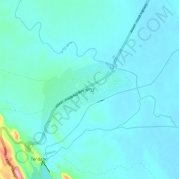
Name: Logiya topographic map, elevation, terrain.

Location: Logiya, Zone 1, Afar Region, Ethiopia (11.68309 40.93610 11.76309 41.01610)

Average elevation: 1,309 ft

Minimum elevation: 1,257 ft

Maximum elevation: 1,781 ft

Other topographic maps

Click on a map to view its topography, its elevation and its terrain.

water way

Ethiopia > Afar Region

Average elevation: 2,589 ft

Danakil Depression

Ethiopia > Afar Region

Average elevation: 479 ft

Zone 3

Ethiopia > Afar Region

Average elevation: 4,035 ft

Danakil Depression

Ethiopia > Afar Region

Average elevation: -344 ft

Mille

Ethiopia > Afar Region > Lower Miele

Average elevation: 1,627 ft

Gear up for your next adventure:

🔊Portable Camp Speaker - Music and alerts at camp
🧭Map Reading Tools - Tools and kits for map navigation
🥾Women's Hiking Boots - Top-rated trail boots with ankle support and superior grip
🪓Survival Multi‑Tool - Versatile tool for camp and trail tasks
🕶️GPS Smartphone Mount - Secure mount for phone navigation

As an Amazon Associate, this site earns from qualifying purchases at no extra cost to you.