Geolocate

Union topographic map

Click on the map to display elevation.

About this map

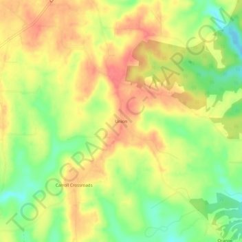
Name: Union topographic map, elevation, terrain.

Location: Union, Franklin County, Alabama, United States (34.35732 -87.59419 34.39732 -87.55419)

Average elevation: 988 ft

Minimum elevation: 873 ft

Maximum elevation: 1,076 ft

Franklin County trails, hiking, mountain biking, running and outdoor activities

Other topographic maps

Click on a map to view its topography, its elevation and its terrain.

Belgreen

United States > Alabama > Franklin County

Average elevation: 768 ft

Vina

United States > Alabama > Franklin County

Average elevation: 692 ft

Hodges

United States > Alabama > Franklin County

Average elevation: 794 ft

Bear Creek

United States > Alabama > Franklin County > Red Bay

Average elevation: 627 ft

Gear up for your next adventure:

🍳Camping Cook Set - Complete cookware for outdoor meals
📡GPS Antenna Upgrade - Enhance GPS reception in remote terrain
🧢Outdoor Hiking Hat - Sun protection hat for outdoor explorers
🚗GPS Dash Cams - Record your scenic drives through mountain passes and canyons
🎒Day Hiking Backpack - Lightweight backpack perfect for day trips and outdoor adventures

As an Amazon Associate, this site earns from qualifying purchases at no extra cost to you.