
Make a donation
Gear up for your next adventure:
As an Amazon Associate, this site earns from qualifying purchases at no extra cost to you.
Pooyamkutty topographic map
Click on the map to display elevation.
Make a donation
Gear up for your next adventure:
As an Amazon Associate, this site earns from qualifying purchases at no extra cost to you.
About this map
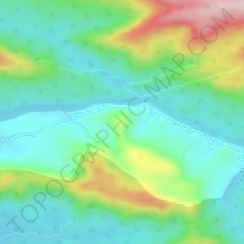
Name: Pooyamkutty topographic map, elevation, terrain.
Location: Pooyamkutty, Kothamangalam, Ernakulam District, Kerala, India (10.16351 76.74943 10.17017 76.78710)
Average elevation: 423 ft
Minimum elevation: 115 ft
Maximum elevation: 1,168 ft
Make a donation
Gear up for your next adventure:
As an Amazon Associate, this site earns from qualifying purchases at no extra cost to you.
Other topographic maps
Click on a map to view its topography, its elevation and its terrain.
Kothamangalam
India > Kerala > Kothamangalam
Kothamangalam is situated in the eastern part of the Ernakulam district. According to the division of the geographical regions of Kerala, Kothamangalam is in a mid-land region. The general topography is hilly.
Average elevation: 112 ft
Make a donation
Gear up for your next adventure:
As an Amazon Associate, this site earns from qualifying purchases at no extra cost to you.
Make a donation
Gear up for your next adventure:
As an Amazon Associate, this site earns from qualifying purchases at no extra cost to you.
Make a donation
Gear up for your next adventure:
As an Amazon Associate, this site earns from qualifying purchases at no extra cost to you.
Edalipparakudy Tribal Settlement, Edamalakudy
India > Kerala > Kothamangalam
Average elevation: 3,911 ft
Make a donation
Gear up for your next adventure:
As an Amazon Associate, this site earns from qualifying purchases at no extra cost to you.
Edamalakkudy
India > Kerala > Kothamangalam
Edamalakudy is located at an elevation of 1100–1700 metres, 22 km north-west of Pettimudi, a village about 4 km west of the Anamudi, the tallest mountain peak in South India on the border of Ernakulam district and Idukki district. Pettimudi was hit by a landslide in 2018 and the debris have not been cleared.…
Average elevation: 3,593 ft
Kothamangalam
India > Kerala > Kothamangalam
Kothamangalam is situated in the eastern part of the Ernakulam district. According to the division of the geographical regions of Kerala, Kothamangalam is in a mid-land region. The general topography is hilly.
Average elevation: 112 ft