Geolocate

Bearden topographic map

Click on the map to display elevation.

About this map

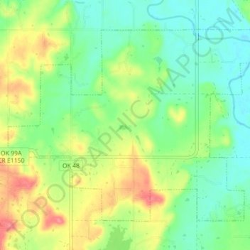
Name: Bearden topographic map, elevation, terrain.

Location: Bearden, Okfuskee County, Oklahoma, United States (35.33357 -96.42356 35.37757 -96.35342)

Average elevation: 863 ft

Minimum elevation: 768 ft

Maximum elevation: 1,017 ft

Okfuskee County trails, hiking, mountain biking, running and outdoor activities

Other topographic maps

Click on a map to view its topography, its elevation and its terrain.

Welty

United States > Oklahoma > Okfuskee County

Average elevation: 745 ft

Gear up for your next adventure:

🚁Photography Drones - Capture stunning aerial views of landforms and topography
🔭Stargazing Telescopes - Perfect for camping in low-light pollution areas shown on maps
🧢Sun Protection Hats - Wide-brimmed and UPF-rated hats for high-altitude sun safety
Solar GPS Watches - Advanced multisport watches with built-in topographic maps
🕶️Glacier Sunglasses - Side shields to protect eyes from high-altitude snow glare

As an Amazon Associate, this site earns from qualifying purchases at no extra cost to you.