Geolocate

Noble topographic map

Click on the map to display elevation.

About this map

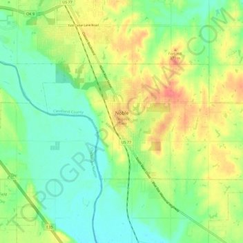
Name: Noble topographic map, elevation, terrain.

Location: Noble, Cleveland County, Oklahoma, 73068, United States (35.11680 -97.42984 35.16070 -97.31778)

Average elevation: 1,129 ft

Minimum elevation: 1,050 ft

Maximum elevation: 1,247 ft

Cleveland County trails, hiking, mountain biking, running and outdoor activities

Other topographic maps

Click on a map to view its topography, its elevation and its terrain.

Norman

United States > Oklahoma > Cleveland County > Norman

Average elevation: 1,168 ft

Moore

United States > Oklahoma > Cleveland County > Moore > Moore

Average elevation: 1,237 ft

Gear up for your next adventure:

🏫Relief Map Kits - Hands-on tools for teaching landforms and elevation
🪶Wildlife Field Guides - Learn animal tracking and species ID
📶Vehicle Signal Boosters - Improve reception in rural areas while driving to trailheads
😴Insulated Sleeping Pads - Compact and warm pads for high-elevation camping
🦶Hiking Gaiters - Keep debris and water out of your boots

As an Amazon Associate, this site earns from qualifying purchases at no extra cost to you.