
Make a donation
Gear up for your next adventure:
As an Amazon Associate, this site earns from qualifying purchases at no extra cost to you.
Port Washington topographic map
Click on the map to display elevation.
Make a donation
Gear up for your next adventure:
As an Amazon Associate, this site earns from qualifying purchases at no extra cost to you.
Port Washington
The city is located on the western shore of Lake Michigan. In northern and southern parts of the city, the coastline is characterized by clay bluffs ranging from 80 feet (24 meters) to 130 feet (40 meters) in height with deep ravines where streams flow into the lake. Clay bluffs are a geological formation characteristic of the Lake Michigan shoreline, and are found in few other areas of the world. Much of the coastline adjacent to the bluffs has mixed gravel and sand beaches. Port Washington's historic downtown in the central part of the city is in the Sauk Creek valley, at a lower elevation than the rest of the city. The valley is a break in the bluffs, providing easy access to the lakeshore, which attracted early settlers to the area. Port Washington's artificial harbor, dredged in 1871 with subsequently constructed breakwaters, is located at the mouth of Sauk Creek, adjacent to downtown.
Make a donation
Gear up for your next adventure:
As an Amazon Associate, this site earns from qualifying purchases at no extra cost to you.
About this map
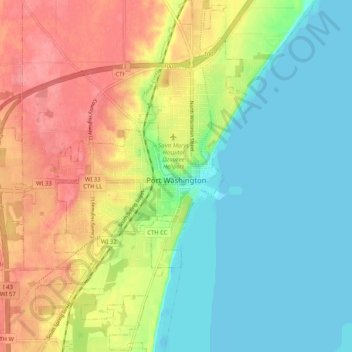
Name: Port Washington topographic map, elevation, terrain.
Average elevation: 673 ft
Minimum elevation: 564 ft
Maximum elevation: 827 ft
Ozaukee County trails, hiking, mountain biking, running and outdoor activities
Make a donation
Gear up for your next adventure:
As an Amazon Associate, this site earns from qualifying purchases at no extra cost to you.
Other topographic maps
Click on a map to view its topography, its elevation and its terrain.