
Make a donation
Gear up for your next adventure:
As an Amazon Associate, this site earns from qualifying purchases at no extra cost to you.
Perm District topographic map
Click on the map to display elevation.
Make a donation
Gear up for your next adventure:
As an Amazon Associate, this site earns from qualifying purchases at no extra cost to you.
About this map
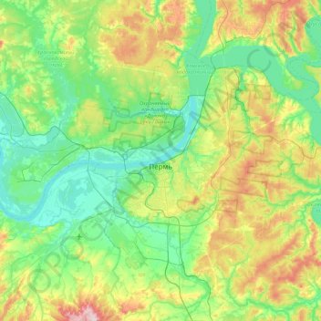
Name: Perm District topographic map, elevation, terrain.
Location: Perm District, Perm Krai, Volga Federal District, Russia (57.86790 55.79892 58.17715 56.65664)
Average elevation: 502 ft
Minimum elevation: 272 ft
Maximum elevation: 1,145 ft
Make a donation
Gear up for your next adventure:
As an Amazon Associate, this site earns from qualifying purchases at no extra cost to you.
Other topographic maps
Click on a map to view its topography, its elevation and its terrain.
Камчатка
Russia > Perm Krai > Gaynsky District
Like most of its namesake peninsula, the basin of the Kamchatka River has at low altitudes a subarctic climate (Köppen Dfc) with short, cool to comfortable summers and freezing, snowy winters.
Average elevation: 591 ft
Make a donation
Gear up for your next adventure:
As an Amazon Associate, this site earns from qualifying purchases at no extra cost to you.