Geolocate

Haddon topographic map

Click on the map to display elevation.

Haddon

In 1890, Benjamin A. Lippincott constructed a passenger station in the center of his land for the Atlantic City Railroad. Then Lippincott, with Charles Hillman, filed a grid street plan with Camden County to develop a community. They named it Haddon Heights because of its proximity to Haddonfield and its high elevation. Large houses were constructed that appealed to prosperous middle-class families moving from the cities. In 1904, Haddon Heights was incorporated as a borough and Lippincott was elected mayor. A small downtown grew near the railroad and the White Horse Pike and eight churches and a synagogue were built. An area of old Centre Township, known as Fairfield Estates, voted in 1926 to become part of Haddon Heights. This land was developed for more single-family housing through the 1940s and 1950s. Even though rail passenger service was suspended in July 1965, Haddon Heights remains a typical turn-of-the-twentieth-century railroad suburb with tree-shaded streets and comfortable homes.

Wikipedia (CC-BY-SA 3.0)

About this map

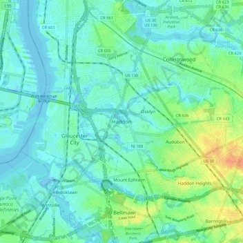
Name: Haddon topographic map, elevation, terrain.

Location: Haddon, Haddon Township, Camden County, New Jersey, 08104, United States (39.85761 -75.13601 39.93761 -75.05601)

Average elevation: 30 ft

Minimum elevation: -13 ft

Maximum elevation: 115 ft

Camden County trails, hiking, mountain biking, running and outdoor activities

Other topographic maps

Click on a map to view its topography, its elevation and its terrain.

Merchantville

United States > New Jersey > Camden County

Average elevation: 66 ft

Pine Hill

United States > New Jersey > Camden County

Average elevation: 128 ft

Stratford

United States > New Jersey > Camden County

Average elevation: 75 ft

Mount Ephraim

United States > New Jersey > Camden County

Average elevation: 33 ft

Audubon

United States > New Jersey > Camden County

Average elevation: 49 ft

Magnolia

United States > New Jersey > Camden County

Average elevation: 75 ft

Brooklawn

United States > New Jersey > Camden County

Average elevation: 16 ft

Lindenwold

United States > New Jersey > Camden County

Average elevation: 108 ft

Clementon

United States > New Jersey > Camden County

Average elevation: 102 ft

Barrington

United States > New Jersey > Camden County

Average elevation: 69 ft

Chesilhurst

United States > New Jersey > Camden County

Average elevation: 141 ft

Somerdale

United States > New Jersey > Camden County

Average elevation: 75 ft

Runnemede

United States > New Jersey > Camden County

Average elevation: 52 ft

Woodlynne

United States > New Jersey > Camden County > Woodlynne

Average elevation: 23 ft

Bellmawr

United States > New Jersey > Camden County

Average elevation: 36 ft

Atco Lake

United States > New Jersey > Camden County

Average elevation: 138 ft

Gear up for your next adventure:

🏫Relief Map Kits - Hands-on tools for teaching landforms and elevation
🔥Camping Stove - Portable stove for camping and backcountry cooking
🎒Gear Packing Cubes - Organize your backpack efficiently
📖Nature Tracking Books - Learn to track wildlife and terrain
🛡️Insect Repellent - Protection against bugs during outdoor activities

As an Amazon Associate, this site earns from qualifying purchases at no extra cost to you.