
Make a donation
Gear up for your next adventure:
As an Amazon Associate, this site earns from qualifying purchases at no extra cost to you.
Pine Hill topographic map
Click on the map to display elevation.
Make a donation
Gear up for your next adventure:
As an Amazon Associate, this site earns from qualifying purchases at no extra cost to you.
About this map
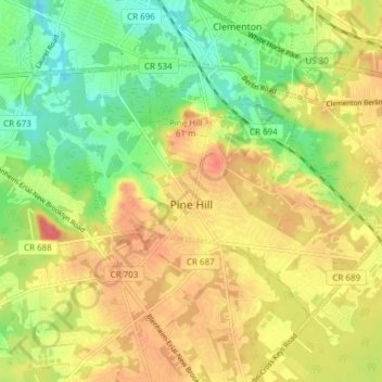
Name: Pine Hill topographic map, elevation, terrain.
Location: Pine Hill, Camden County, New Jersey, 08021, United States (39.76714 -75.02369 39.80539 -74.94782)
Average elevation: 128 ft
Minimum elevation: 26 ft
Maximum elevation: 217 ft
Camden County trails, hiking, mountain biking, running and outdoor activities
Make a donation
Gear up for your next adventure:
As an Amazon Associate, this site earns from qualifying purchases at no extra cost to you.
Other topographic maps
Click on a map to view its topography, its elevation and its terrain.
Make a donation
Gear up for your next adventure:
As an Amazon Associate, this site earns from qualifying purchases at no extra cost to you.
Cooper River Lake
United States > New Jersey > Camden County > Cherry Hill Township > Stoys Landing
Average elevation: 33 ft
Make a donation
Gear up for your next adventure:
As an Amazon Associate, this site earns from qualifying purchases at no extra cost to you.
Locust Grove
United States > New Jersey > Camden County > Cherry Hill Township
Average elevation: 82 ft
Stoys Landing
United States > New Jersey > Camden County > Cherry Hill Township
Average elevation: 46 ft
Make a donation
Gear up for your next adventure:
As an Amazon Associate, this site earns from qualifying purchases at no extra cost to you.
Make a donation
Gear up for your next adventure:
As an Amazon Associate, this site earns from qualifying purchases at no extra cost to you.
Make a donation
Gear up for your next adventure:
As an Amazon Associate, this site earns from qualifying purchases at no extra cost to you.
Haddon
United States > New Jersey > Camden County
In 1890, Benjamin A. Lippincott constructed a passenger station in the center of his land for the Atlantic City Railroad. Then Lippincott, with Charles Hillman, filed a grid street plan with Camden County to develop a community. They named it Haddon Heights because of its proximity to Haddonfield and its high…
Average elevation: 30 ft
Make a donation
Gear up for your next adventure:
As an Amazon Associate, this site earns from qualifying purchases at no extra cost to you.