Geolocate

Troy topographic map

Click on the map to display elevation.

About this map

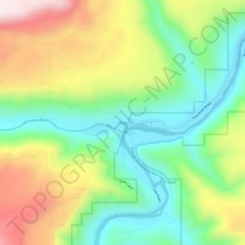
Name: Troy topographic map, elevation, terrain.

Location: Troy, Wallowa County, Oregon, United States (45.92687 -117.47148 45.96687 -117.43148)

Average elevation: 2,333 ft

Minimum elevation: 1,545 ft

Maximum elevation: 3,553 ft

Wallowa County trails, hiking, mountain biking, running and outdoor activities

Other topographic maps

Click on a map to view its topography, its elevation and its terrain.

Enterprise

United States > Oregon > Wallowa County

Average elevation: 3,812 ft

Gear up for your next adventure:

👟Men's Trail Runners - Lightweight footwear for fast-paced exploration and light hiking
GPS Sports Watch - GPS watch for running, hiking and training
🛰️Handheld GPS Units - Professional satellite navigators for precise backcountry mapping
🪶Fire Starter Kit - Reliable fire starter for survival and camping
🧭Orienteering Set - Complete compass and map reading kit

As an Amazon Associate, this site earns from qualifying purchases at no extra cost to you.