Geolocate

Enterprise topographic map

Click on the map to display elevation.

About this map

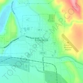
Name: Enterprise topographic map, elevation, terrain.

Location: Enterprise, Wallowa County, Oregon, United States (45.41475 -117.29776 45.43579 -117.26192)

Average elevation: 3,812 ft

Minimum elevation: 3,691 ft

Maximum elevation: 4,094 ft

Wallowa County trails, hiking, mountain biking, running and outdoor activities

Other topographic maps

Click on a map to view its topography, its elevation and its terrain.

Troy

United States > Oregon > Wallowa County

Average elevation: 2,333 ft

Big Canyon Fish Weir

United States > Oregon > Wallowa County

Average elevation: 3,097 ft

Imnaha

United States > Oregon > Wallowa County

Average elevation: 2,825 ft

Gear up for your next adventure:

🔭Stargazing Telescopes - Perfect for camping in low-light pollution areas shown on maps
🍳Camping Cook Set - Complete cookware for outdoor meals
🔋Solar Power Banks - Keep your GPS and phone charged in remote wilderness areas
🪶Paracord Bracelet - Survival bracelet with built‑in tools
🥩Freeze-Dried Meals - Nutritious and lightweight food for remote expeditions

As an Amazon Associate, this site earns from qualifying purchases at no extra cost to you.