
方山县 topographic map
Interactive map
Click on the map to display elevation.
About this map
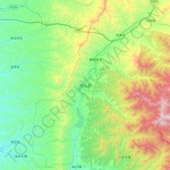
Name: 方山县 topographic map, elevation, terrain.
Location: 方山县, 吕梁市, 山西省, 中国 (37.73438 111.07803 38.05438 111.39803)
Average elevation: 4,564 ft
Minimum elevation: 3,009 ft
Maximum elevation: 8,297 ft
地处吕梁山中部,最高山峰为关帝山,海拔2830米。
Other topographic maps
Click on a map to view its topography, its elevation and its terrain.