
Corinth topographic map
Click on the map to display elevation.
About this map
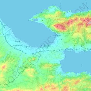
Name: Corinth topographic map, elevation, terrain.
Average elevation: 607 ft
Minimum elevation: -10 ft
Maximum elevation: 4,449 ft
Other topographic maps
Click on a map to view its topography, its elevation and its terrain.
Municipal Unit of Loutraki - Perachora
Greece > Peloponnese, Western Greece and the Ionian > Corinthia Regional Unit
Average elevation: 558 ft
Corinth
Greece > Peloponnese, Western Greece and the Ionian > Corinthia Regional Unit
Average elevation: 69 ft
Municipal Unit of Assos - Lechaio
Greece > Peloponnese, Western Greece and the Ionian > Corinthia Regional Unit
Average elevation: 430 ft
Municipal Unit of Evrostina
Greece > Peloponnese, Western Greece and the Ionian > Corinthia Regional Unit
Average elevation: 2,293 ft
Corinth
Greece > Peloponnese, Western Greece and the Ionian > Corinthia Regional Unit
Average elevation: 69 ft
Corinth Canal
Greece > Peloponnese, Western Greece and the Ionian > Corinthia Regional Unit > Municipal Unit of Loutraki - Perachora > Γαλότα
Average elevation: 200 ft
Municipal Unit of Agioi Theodoroi
Greece > Peloponnese, Western Greece and the Ionian > Corinthia Regional Unit
Average elevation: 1,220 ft
Municipal Unit of Saronikos
Greece > Peloponnese, Western Greece and the Ionian > Corinthia Regional Unit
Average elevation: 1,460 ft
Municipal Unit of Velos
Greece > Peloponnese, Western Greece and the Ionian > Corinthia Regional Unit
Average elevation: 906 ft
Municipal Unit of Corinth
Greece > Peloponnese, Western Greece and the Ionian > Corinthia Regional Unit
Average elevation: 413 ft
Community of Ano Trikala
Greece > Peloponnese, Western Greece and the Ionian > Corinthia Regional Unit > Municipal Unit of Xylokastro
Average elevation: 5,089 ft