Geolocate

King topographic map

Click on the map to display elevation.

About this map

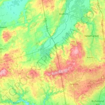
Name: King topographic map, elevation, terrain.

Location: King, East Gwillimbury, York Region, Golden Horseshoe, Ontario, Canada (43.87440 -79.77550 44.15050 -79.47777)

Average elevation: 873 ft

Minimum elevation: 663 ft

Maximum elevation: 1,211 ft

Other topographic maps

Click on a map to view its topography, its elevation and its terrain.

Holland Landing

Canada > Ontario > York Region > East Gwillimbury

Average elevation: 801 ft

Sharon

Canada > Ontario > York Region > East Gwillimbury

Average elevation: 879 ft

Nobleton

Canada > Ontario > York Region > King

Average elevation: 866 ft

Gorham St Open Space

Canada > Ontario > York Region > Newmarket

Average elevation: 827 ft

Gear up for your next adventure:

🪑Ultralight Camp Chairs - Portable seating for resting after a long day of mapping
🦶Carbon Trekking Poles - Reduce knee impact on steep descents with ultra-light poles
🧭Compass with Lanyard - Easy‑carry compass for navigation
🏕️Tent Footprint - Protect your tent base from wear
🪶LED Camping Lantern - Bright lantern for camp lighting

As an Amazon Associate, this site earns from qualifying purchases at no extra cost to you.