Geolocate

Canton topographic map

Click on the map to display elevation.

About this map

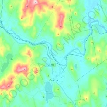
Name: Canton topographic map, elevation, terrain.

Location: Canton, Oxford County, Maine, 04221, United States (44.40697 -70.36033 44.54034 -70.23890)

Average elevation: 666 ft

Minimum elevation: 335 ft

Maximum elevation: 1,785 ft

Oxford County trails, hiking, mountain biking, running and outdoor activities

Other topographic maps

Click on a map to view its topography, its elevation and its terrain.

West Bethel

United States > Maine > Oxford County > Bethel

Average elevation: 827 ft

Record Hill

United States > Maine > Oxford County > Byron

Average elevation: 1,565 ft

Sunday River

United States > Maine > Oxford County > Bethel

Average elevation: 915 ft

Bryant Pond

United States > Maine > Oxford County > Woodstock

Average elevation: 886 ft

Grover Hill

United States > Maine > Oxford County

Average elevation: 817 ft

Old Speck Mountain

United States > Maine > Oxford County

Average elevation: 3,094 ft

Boston Hills

United States > Maine > Oxford County > Denmark

Average elevation: 446 ft

Sugarloaf

United States > Maine > Oxford County > Dixfield

Average elevation: 778 ft

Gear up for your next adventure:

🗃️Trail First Aid Kit - Essential kit for outdoor injuries and emergencies
📱Heavy-Duty Phone Cases - Drop-proof and waterproof protection for outdoor navigation
🧯Portable Fire Pit - Compact fire pit for camping spots
👓Polarized Sunglasses - Outdoor sunglasses for glare reduction
🧼Biodegradable Camping Soap - Eco‑friendly soap for outdoor hygiene

As an Amazon Associate, this site earns from qualifying purchases at no extra cost to you.