
Make a donation
Gear up for your next adventure:
As an Amazon Associate, this site earns from qualifying purchases at no extra cost to you.
Muntanyola topographic map
Click on the map to display elevation.
Make a donation
Gear up for your next adventure:
As an Amazon Associate, this site earns from qualifying purchases at no extra cost to you.
Muntanyola
The village of Muntanyola is a-typical in that it does not have a center. 75% of the municipality's area consists of forested hills between 650 and 1000 m. altitude, with scattered farms and fields. The build-up area is in the higher elevations and mainly consists of two real estate developments - in Spanish: 'urbanizations' - called Muntanyola and Fontanelles, respectively. Both these neighbourhoods consist of lanes with upmarket free-standing villa's with large gardens. Centrally located in the 'Muntanyola urbanization' are the school, a tennis court, sports hall, swimming pool, playground and restaurant. The church and town hall stand rather isolated in the hills on the northern side of the Muntanyola-development. The municipality also includes the old hamlet of Múnter in its lower elevations, sloping down to the Plain of Vic (Plana de Vic). The municipality is also odd in that its territory consists of four non-contiguous areas, i.e. a main area with three exclaves. Muntanyola, Fontanelles and Múnter are all in the main area, but Múnter can be reached from Muntanyola by a rural path or via the territory of the adjacent municipality of Tona
Make a donation
Gear up for your next adventure:
As an Amazon Associate, this site earns from qualifying purchases at no extra cost to you.
About this map
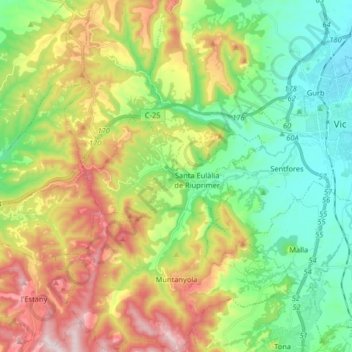
Name: Muntanyola topographic map, elevation, terrain.
Location: Muntanyola, Osona, Barcelona, Catalonia, 08529, Spain (41.85207 2.09069 41.97270 2.23168)
Average elevation: 2,224 ft
Minimum elevation: 1,542 ft
Maximum elevation: 3,376 ft
Make a donation
Gear up for your next adventure:
As an Amazon Associate, this site earns from qualifying purchases at no extra cost to you.
Other topographic maps
Click on a map to view its topography, its elevation and its terrain.