
Szada topographic map
Click on the map to display elevation.
About this map
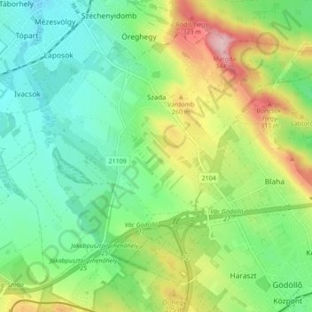
Name: Szada topographic map, elevation, terrain.
Average elevation: 735 ft
Minimum elevation: 528 ft
Maximum elevation: 1,135 ft
Other topographic maps
Click on a map to view its topography, its elevation and its terrain.
Pannonian Basin
Pannonian basin vs Carpathian basin: On the territory of present-day Hungary the ancient Roman Pannonia province was located only on Transdanubian territories, however the Great Hungarian Plain was not part of Pannonia province. This comprises less than 29% of modern Hungary, therefore Hungarian geographers…
Average elevation: 325 ft