Geolocate

Vinchos topographic map

Click on the map to display elevation.

About this map

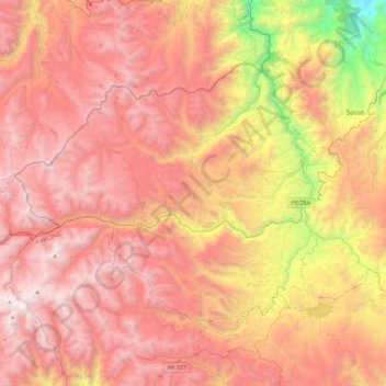
Name: Vinchos topographic map, elevation, terrain.

Location: Vinchos, Province of Huamanga, Ayacucho, Peru (-13.45314 -74.68607 -13.15036 -74.27363)

Average elevation: 12,349 ft

Minimum elevation: 8,117 ft

Maximum elevation: 15,899 ft

Other topographic maps

Click on a map to view its topography, its elevation and its terrain.

Atacocha

Peru > Ayacucho

Average elevation: 10,581 ft

Mejorada

Peru > Ayacucho > Unión Progreso

Average elevation: 3,885 ft

Palmadera

Peru > Ayacucho

Average elevation: 12,231 ft

Guitarrayoc

Peru > Ayacucho > Uspa

Average elevation: 4,974 ft

Santa Rosa

Peru > Ayacucho > San Juan Bautista

Average elevation: 9,160 ft

Guitarrayoc

Peru > Ayacucho > Uspa

Average elevation: 4,974 ft

Unya

Peru > Ayacucho

Average elevation: 9,603 ft

Pampas

Peru > Ayacucho > Luis Carranza

Average elevation: 10,062 ft

Cancha Cancha

Peru > Ayacucho

Average elevation: 11,050 ft

Tambobamba

Peru > Ayacucho

Average elevation: 9,724 ft

La Vega

Peru > Ayacucho

Average elevation: 9,459 ft

Santa Fe

Peru > Ayacucho

Average elevation: 14,836 ft

Apachita

Peru > Ayacucho > Vilcas Huamán > Alto Perú > Apachita

Average elevation: 11,483 ft

Villa Virgen

Peru > Ayacucho > Llochegua

Average elevation: 2,060 ft

Gear up for your next adventure:

🥾Women's Hiking Boots - Top-rated trail boots with ankle support and superior grip
🪶Compact Camp Shovel - Folding shovel for campsite tasks
📶Vehicle Signal Boosters - Improve reception in rural areas while driving to trailheads
🪑Portable Camp Table - Compact table for campsite meals
👟Trail Running Shoes - Lightweight shoes for trail runners

As an Amazon Associate, this site earns from qualifying purchases at no extra cost to you.