
Flower Ridge topographic map
Click on the map to display elevation.
About this map
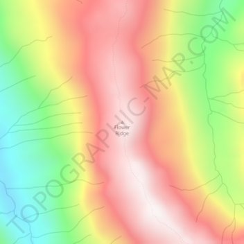
Name: Flower Ridge topographic map, elevation, terrain.
Average elevation: 3,593 ft
Minimum elevation: 1,801 ft
Maximum elevation: 5,030 ft
Other topographic maps
Click on a map to view its topography, its elevation and its terrain.
Oyster River
Canada > British Columbia > Strathcona Regional District > Area D (Oyster Bay/Buttle Lake) > Oyster River
Average elevation: 79 ft
Arnica Lake
Canada > British Columbia > Strathcona Regional District > Area D (Oyster Bay/Buttle Lake)
Average elevation: 3,871 ft
Upper Campbell Lake
Canada > British Columbia > Strathcona Regional District > Area D (Oyster Bay/Buttle Lake)
Average elevation: 2,073 ft
Moving Glacier
Canada > British Columbia > Strathcona Regional District > Area D (Oyster Bay/Buttle Lake)
Average elevation: 5,049 ft