
Toomaline Upper topographic map
Click on the map to display elevation.
About this map
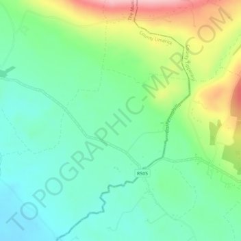
Name: Toomaline Upper topographic map, elevation, terrain.
Average elevation: 400 ft
Minimum elevation: 217 ft
Maximum elevation: 787 ft
Other topographic maps
Click on a map to view its topography, its elevation and its terrain.
Kilcruaig
Ireland > County Limerick > The Municipal District of Cappamore — Kilmallock
Average elevation: 656 ft
Knockadea
Ireland > County Limerick > The Municipal District of Cappamore — Kilmallock
Average elevation: 666 ft
Pallasgreen
Ireland > County Limerick > The Municipal District of Cappamore — Kilmallock
Average elevation: 236 ft
Galtymore
Ireland > County Limerick > The Municipal District of Cappamore — Kilmallock
Galtymore or Galteemore (Irish: Cnoc Mór na nGaibhlte, meaning 'big hill of the Galtees') is a mountain in the province of Munster, Ireland. At 917.9 metres (3,011 ft 6 in), it is one of Ireland's highest mountains, being the 12th-highest on the Arderin list, and 14th-highest on the Vandeleur-Lynam list.…
Average elevation: 1,949 ft
Aherlow
Ireland > County Limerick > The Municipal District of Cappamore — Kilmallock
Average elevation: 463 ft
Clare Glens
Ireland > County Limerick > The Municipal District of Cappamore — Kilmallock
Average elevation: 407 ft
Ardpatrick
Ireland > County Limerick > The Municipal District of Cappamore — Kilmallock
Average elevation: 554 ft
Bruff
Ireland > County Limerick > The Municipal District of Cappamore — Kilmallock
Average elevation: 223 ft
Bruree
Ireland > County Limerick > The Municipal District of Cappamore — Kilmallock
Average elevation: 203 ft