
Ardpatrick topographic map
Click on the map to display elevation.
About this map
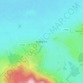
Name: Ardpatrick topographic map, elevation, terrain.
Average elevation: 554 ft
Minimum elevation: 364 ft
Maximum elevation: 1,404 ft
Other topographic maps
Click on a map to view its topography, its elevation and its terrain.
Kilmallock
Ireland > County Limerick > The Municipal District of Cappamore — Kilmallock
Average elevation: 292 ft
Kilmurry
Ireland > County Limerick > The Municipal District of Cappamore — Kilmallock
Average elevation: 295 ft
Kilfinnane
Ireland > County Limerick > The Municipal District of Cappamore — Kilmallock
At an elevation of over 150 metres (500 ft), Kilfinnane is the highest town in County Limerick. It is surrounded on three sides by the Ballyhoura Mountains, and on the fourth side is the "Golden Vale" region that runs through Counties Limerick, Cork, and Tipperary.
Average elevation: 525 ft
Darranstown
Ireland > County Limerick > The Municipal District of Cappamore — Kilmallock
Average elevation: 354 ft
Ballylanders
Ireland > County Limerick > The Municipal District of Cappamore — Kilmallock
Average elevation: 515 ft
Knockainy
Ireland > County Limerick > The Municipal District of Cappamore — Kilmallock
Average elevation: 282 ft
Drombane
Ireland > County Limerick > The Municipal District of Cappamore — Kilmallock
Average elevation: 164 ft
Aherlow
Ireland > County Limerick > The Municipal District of Cappamore — Kilmallock
Average elevation: 463 ft
Cullane South
Ireland > County Limerick > The Municipal District of Cappamore — Kilmallock
Average elevation: 499 ft
Clare Glens
Ireland > County Limerick > The Municipal District of Cappamore — Kilmallock
Average elevation: 407 ft
Glenstal
Ireland > County Limerick > The Municipal District of Cappamore — Kilmallock
Average elevation: 482 ft
Coolnahila (Palmer)
Ireland > County Limerick > The Municipal District of Cappamore — Kilmallock
Average elevation: 128 ft
Coolattin
Ireland > County Limerick > The Municipal District of Cappamore — Kilmallock
Average elevation: 728 ft
Caherconlish
Ireland > County Limerick > The Municipal District of Cappamore — Kilmallock
Average elevation: 259 ft
Coolfree
Ireland > County Limerick > The Municipal District of Cappamore — Kilmallock
Average elevation: 833 ft
Tobernea
Ireland > County Limerick > The Municipal District of Cappamore — Kilmallock
Average elevation: 305 ft
Anglesborough
Ireland > County Limerick > The Municipal District of Cappamore — Kilmallock
Average elevation: 751 ft
Barna
Ireland > County Limerick > The Municipal District of Cappamore — Kilmallock
Average elevation: 817 ft
Dromin
Ireland > County Limerick > The Municipal District of Cappamore — Kilmallock
Average elevation: 240 ft
Garranbane
Ireland > County Limerick > The Municipal District of Cappamore — Kilmallock
Average elevation: 469 ft
Ballyvalode
Ireland > County Limerick > The Municipal District of Cappamore — Kilmallock
Average elevation: 217 ft
Ballysallagh
Ireland > County Limerick > The Municipal District of Cappamore — Kilmallock
Average elevation: 262 ft
Knocknascrow
Ireland > County Limerick > The Municipal District of Cappamore — Kilmallock
Average elevation: 1,004 ft
Tullabeg
Ireland > County Limerick > The Municipal District of Cappamore — Kilmallock
Average elevation: 220 ft
Oola
Ireland > County Limerick > The Municipal District of Cappamore — Kilmallock
Average elevation: 253 ft
Nicker
Ireland > County Limerick > The Municipal District of Cappamore — Kilmallock
Average elevation: 272 ft
Kilmallock
Ireland > County Limerick > The Municipal District of Cappamore — Kilmallock
Average elevation: 295 ft
Muingacree
Ireland > County Limerick > The Municipal District of Cappamore — Kilmallock
Average elevation: 879 ft
Kilflynn Particles Parish Union
Ireland > County Limerick > The Municipal District of Cappamore — Kilmallock
Average elevation: 692 ft
Toomaline Upper
Ireland > County Limerick > The Municipal District of Cappamore — Kilmallock
Average elevation: 400 ft
Pallasbeg
Ireland > County Limerick > The Municipal District of Cappamore — Kilmallock
Average elevation: 161 ft
Ballinscaula
Ireland > County Limerick > The Municipal District of Cappamore — Kilmallock
Average elevation: 348 ft
Ballyshoneen
Ireland > County Limerick > The Municipal District of Cappamore — Kilmallock
Average elevation: 259 ft
Doon South
Ireland > County Limerick > The Municipal District of Cappamore — Kilmallock
Average elevation: 331 ft
Anglesborough
Ireland > County Limerick > The Municipal District of Cappamore — Kilmallock
Average elevation: 751 ft
Doon
Ireland > County Limerick > The Municipal District of Cappamore — Kilmallock
Average elevation: 367 ft
Brickfield
Ireland > County Limerick > The Municipal District of Cappamore — Kilmallock
Average elevation: 404 ft
Mounteagle
Ireland > County Limerick > The Municipal District of Cappamore — Kilmallock
Average elevation: 207 ft
Dead
Ireland > County Limerick > The Municipal District of Cappamore — Kilmallock
Average elevation: 203 ft