Geolocate

新兴区 topographic map

Interactive map

Click on the map to display elevation.

About this map

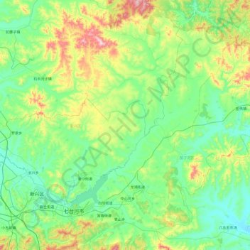
Name: 新兴区 topographic map, elevation, terrain.

Location: 新兴区, 七台河市, 黑龙江省, 154600, 中国 (45.73814 130.67864 46.24879 131.61925)

Average elevation: 879 ft

Minimum elevation: 420 ft

Maximum elevation: 2,530 ft

Other topographic maps

Click on a map to view its topography, its elevation and its terrain.

中国 > 黑龙江省 > 七台河市

水, 东胜街道, 新富街道, 茄子河区, 七台河市, 黑龙江省, 154600, 中国

Average elevation: 682 ft

勃利县

中国 > 黑龙江省 > 七台河市

勃利县, 七台河市, 黑龙江省, 154600, 中国

Average elevation: 981 ft

茄子河区

中国 > 黑龙江省 > 七台河市

茄子河区, 七台河市, 黑龙江省, 154600, 中国

Average elevation: 876 ft

越秀街道

中国 > 黑龙江省 > 七台河市

越秀街道, 新兴区, 七台河市, 黑龙江省, 中国

Average elevation: 564 ft

龙头村

中国 > 黑龙江省 > 七台河市 > 龙头村

龙头村, 七台河市, 黑龙江省, 中国

Average elevation: 518 ft

七台河市

中国 > 黑龙江省 > 七台河市

七台河市, 桃山区, 七台河市, 黑龙江省, 中国

Average elevation: 883 ft