Geolocate

Papaya topographic map

Click on the map to display elevation.

About this map

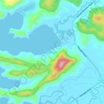
Name: Papaya topographic map, elevation, terrain.

Location: Papaya, Nasugbu, Batangas, Calabarzon, 4231, Philippines (14.15478 120.58811 14.19478 120.62811)

Average elevation: 128 ft

Minimum elevation: -7 ft

Maximum elevation: 873 ft

Other topographic maps

Click on a map to view its topography, its elevation and its terrain.

Palico River

Philippines > Batangas > Nasugbu > Reparo

Average elevation: 144 ft

Pico de Loro Beach

Philippines > Batangas > Nasugbu

Average elevation: 141 ft

Fortune Island

Philippines > Batangas > Nasugbu

Average elevation: 3 ft

Batulao

Philippines > Batangas > Nasugbu

Average elevation: 1,742 ft

Talamitam

Philippines > Batangas > Nasugbu > Kayrilaw

Average elevation: 1,076 ft

Fortune Island

Philippines > Batangas > Nasugbu

Average elevation: 3 ft

Gear up for your next adventure:

🎒Trekking Poles - Sturdy poles for balance and stability on rough terrain
🦟Ultrasonic Repellers - Create a bug-free zone at your camp or rest stop
🥩Freeze-Dried Meals - Nutritious and lightweight food for remote expeditions
🎒Day Hiking Backpack - Lightweight backpack perfect for day trips and outdoor adventures
🪑Portable Camp Table - Compact table for campsite meals

As an Amazon Associate, this site earns from qualifying purchases at no extra cost to you.