Geolocate

Batulao topographic map

Click on the map to display elevation.

About this map

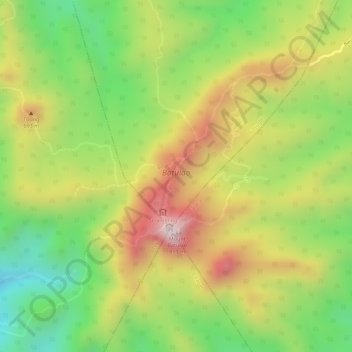
Name: Batulao topographic map, elevation, terrain.

Location: Batulao, Nasugbu, Batangas, Calabarzon, 4231, Philippines (14.03525 120.79732 14.05342 120.81191)

Average elevation: 1,742 ft

Minimum elevation: 948 ft

Maximum elevation: 2,543 ft

Other topographic maps

Click on a map to view its topography, its elevation and its terrain.

Tumalim

Philippines > Batangas > Nasugbu

Average elevation: 253 ft

Munting Indang

Philippines > Batangas > Nasugbu

Average elevation: 223 ft

Mataas na Pulo

Philippines > Batangas > Nasugbu

Average elevation: 331 ft

Cariliao

Philippines > Batangas > Nasugbu

Average elevation: 1,161 ft

Natipuan Cove

Philippines > Batangas > Nasugbu

Average elevation: 89 ft

Kaylaway

Philippines > Batangas > Nasugbu

Average elevation: 1,414 ft

Calayo

Philippines > Batangas > Nasugbu

Average elevation: 161 ft

Dayap

Philippines > Batangas > Nasugbu

Average elevation: 141 ft

Bunducan

Philippines > Batangas > Nasugbu

Average elevation: 128 ft

Talangan

Philippines > Batangas > Nasugbu

Average elevation: 26 ft

Tala

Philippines > Batangas > Nasugbu

Average elevation: 207 ft

Mount Talamitam

Philippines > Batangas > Nasugbu

Average elevation: 1,224 ft

Mount Pico de Loro

Philippines > Batangas > Nasugbu

Mount Pico de Loro, also known as Mount Palay-Palay, is a dormant volcano located on the border of Cavite and Batangas, in the island of Luzon, Philippines. It is the highest mountain in the province of Cavite, with an elevation of 2,257 ft (688 m) above sea level and the highest peak of the Mounts…

Average elevation: 1,178 ft

Fortune Island

Philippines > Batangas > Nasugbu

Average elevation: 3 ft

Kayrilaw

Philippines > Batangas > Nasugbu

Average elevation: 1,040 ft

Panuca

Philippines > Batangas > Nasugbu > Butucan

Average elevation: 217 ft

Looc

Philippines > Batangas > Nasugbu

Average elevation: 171 ft

Balaytigue

Philippines > Batangas > Nasugbu

Average elevation: 75 ft

Papaya

Philippines > Batangas > Nasugbu

Average elevation: 128 ft

Utod

Philippines > Batangas > Nasugbu

Average elevation: 384 ft

Cogonan

Philippines > Batangas > Nasugbu

Average elevation: 43 ft

Banilad

Philippines > Batangas > Nasugbu

Average elevation: 325 ft

Balokbalok

Philippines > Batangas > Nasugbu > Putat

Average elevation: 75 ft

Bulihan

Philippines > Batangas > Nasugbu > Bulihan

Average elevation: 335 ft

Wawa

Philippines > Batangas > Nasugbu > Wawa

Average elevation: 16 ft

Reparo

Philippines > Batangas > Nasugbu

Average elevation: 125 ft

Balaytigue

Philippines > Batangas > Nasugbu

Average elevation: 75 ft

Cogonan

Philippines > Batangas > Nasugbu

Average elevation: 43 ft

Looc

Philippines > Batangas > Nasugbu

Average elevation: 171 ft

Balaytigue

Philippines > Batangas > Nasugbu

Average elevation: 75 ft

Mount Talamitam

Philippines > Batangas > Nasugbu

Average elevation: 1,224 ft

Mataas na Pulo

Philippines > Batangas > Nasugbu

Average elevation: 331 ft

Kaylaway

Philippines > Batangas > Nasugbu

Average elevation: 1,414 ft

Munting Indang

Philippines > Batangas > Nasugbu

Average elevation: 223 ft

Fortune Island

Philippines > Batangas > Nasugbu

Average elevation: 3 ft

Gear up for your next adventure:

☀️Outdoor Sunscreen - High protection sunscreen for outdoor activities
🧢Outdoor Hiking Hat - Sun protection hat for outdoor explorers
🔌Solar Panel Charger - Charge gear sustainably outdoors
🎒Waterproof Dry Bags - Keep your electronics and maps dry inside your pack
🥤Water Filter Bottle - All‑in‑one filter bottle for safe hydration

As an Amazon Associate, this site earns from qualifying purchases at no extra cost to you.