
Export topographic map
Click on the map to display elevation.
Export
Export is characterized by a varied terrain that reflects its location in the Allegheny Plateau region. The borough sits at an average elevation of around 1,122 feet (342 meters) and features rolling hills and valleys typical of southwestern Pennsylvania's topography. The surrounding landscape is marked by gentle slopes and a mix of wooded areas and open fields, providing a picturesque setting that transitions into more rugged terrain as you move toward the nearby hills. The area is also influenced by local waterways, which have carved out small valleys and contribute to the region's rich biodiversity.
About this map
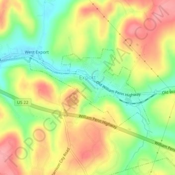
Name: Export topographic map, elevation, terrain.
Average elevation: 1,122 ft
Minimum elevation: 948 ft
Maximum elevation: 1,289 ft
Westmoreland County trails, hiking, mountain biking, running and outdoor activities
Other topographic maps
Click on a map to view its topography, its elevation and its terrain.
Armbrust
United States > Pennsylvania > Westmoreland County > Hempfield Township
Average elevation: 1,083 ft
Circleville
United States > Pennsylvania > Westmoreland County > North Huntingdon Township
Average elevation: 1,093 ft
Donegal Lake
United States > Pennsylvania > Westmoreland County > Donegal Township
Average elevation: 1,617 ft
Bessemer
United States > Pennsylvania > Westmoreland County > East Huntingdon Township
Average elevation: 1,122 ft
Acme
United States > Pennsylvania > Westmoreland County > Mount Pleasant Township
Average elevation: 1,919 ft
Stahlstown
United States > Pennsylvania > Westmoreland County > Cook Township
Average elevation: 1,686 ft
Twin Lakes Park
United States > Pennsylvania > Westmoreland County > Hempfield Township > Luxor > Georges Station
Average elevation: 1,204 ft
West Export
United States > Pennsylvania > Westmoreland County > Murrysville
Average elevation: 1,119 ft
Kecksburg
United States > Pennsylvania > Westmoreland County > Mount Pleasant Township
Average elevation: 1,325 ft
Newlonsburg
United States > Pennsylvania > Westmoreland County > Murrysville
Average elevation: 1,112 ft
Southwest
United States > Pennsylvania > Westmoreland County > Mount Pleasant Township
Average elevation: 1,102 ft
Southwest
United States > Pennsylvania > Westmoreland County > Mount Pleasant Township
Average elevation: 1,102 ft
Tarrs
United States > Pennsylvania > Westmoreland County > East Huntingdon Township
Average elevation: 1,168 ft
Chestnut Ridge
United States > Pennsylvania > Westmoreland County > Fairfield Township
Average elevation: 1,529 ft
Millwood
United States > Pennsylvania > Westmoreland County > Derry Township
Average elevation: 1,335 ft
Buckeye
United States > Pennsylvania > Westmoreland County > East Huntingdon Township
Average elevation: 1,109 ft
Perryville
United States > Pennsylvania > Westmoreland County > Bell Township
Average elevation: 1,198 ft
Morewood
United States > Pennsylvania > Westmoreland County > East Huntingdon Township
Average elevation: 1,171 ft
Painter Rock Hill
United States > Pennsylvania > Westmoreland County > Donegal Township
Average elevation: 2,562 ft
United
United States > Pennsylvania > Westmoreland County > Mount Pleasant Township
Average elevation: 1,070 ft
Turkeytown
United States > Pennsylvania > Westmoreland County > South Huntingdon Township
Average elevation: 1,040 ft
Alverton
United States > Pennsylvania > Westmoreland County > East Huntingdon Township
Average elevation: 1,184 ft
Collinsburg
United States > Pennsylvania > Westmoreland County > Rostraver Township
Average elevation: 925 ft
Maplewood Terrace
United States > Pennsylvania > Westmoreland County > Hempfield Township > Maplewood Terrace
Average elevation: 1,135 ft
Bessemer
United States > Pennsylvania > Westmoreland County > East Huntingdon Township > Bessemer
Average elevation: 1,122 ft
Camp Jo-Ann
United States > Pennsylvania > Westmoreland County > Murrysville > Camp Jo-Ann
Average elevation: 1,125 ft
Keystone State Park
United States > Pennsylvania > Westmoreland County > Derry Township
Average elevation: 1,155 ft