Geolocate

Hochatown topographic map

Click on the map to display elevation.

👉 Easily get elevation data in JSON, GeoTIFF and KML formats using Elevation API
Thank you for supporting this site ❤️
Make a donation

About this map

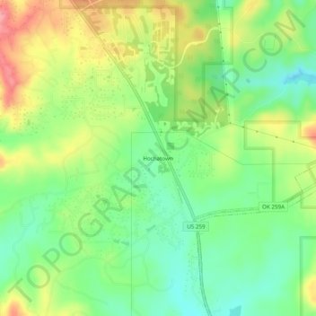
Name: Hochatown topographic map, elevation, terrain.

Location: Hochatown, McCurtain County, Oklahoma, United States (34.13233 -94.77272 34.17233 -94.73272)

Average elevation: 722 ft

Minimum elevation: 591 ft

Maximum elevation: 906 ft

McCurtain County trails, hiking, mountain biking, running and outdoor activities

Other topographic maps

Click on a map to view its topography, its elevation and its terrain.

Hochatown

United States > Oklahoma > McCurtain County

Average elevation: 715 ft

Garvin

United States > Oklahoma > McCurtain County > Garvin

Average elevation: 472 ft

Gear up for your next adventure:

🏫Relief Map Kits - Hands-on tools for teaching landforms and elevation
📖Nature Tracking Books - Learn to track wildlife and terrain
Solar GPS Watches - Advanced multisport watches with built-in topographic maps
🪵Folding Camp Saw - Compact saw for wood and campsite work
🦶Carbon Trekking Poles - Reduce knee impact on steep descents with ultra-light poles

As an Amazon Associate, this site earns from qualifying purchases at no extra cost to you.