
Broken Bow Lake topographic map
Interactive map
Click on the map to display elevation.
About this map
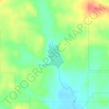
Name: Broken Bow Lake topographic map, elevation, terrain.
Location: Broken Bow Lake, McCurtain County, Oklahoma, United States (34.06359 -94.77064 34.07027 -94.76410)
Average elevation: 518 ft
Minimum elevation: 443 ft
Maximum elevation: 627 ft
Other topographic maps
Click on a map to view its topography, its elevation and its terrain.
Broken Bow
United States > Oklahoma > McCurtain County
Broken Bow, McCurtain County, Oklahoma, United States
Average elevation: 509 ft
Hochatown
United States > Oklahoma > McCurtain County
Hochatown, McCurtain County, Oklahoma, United States
Average elevation: 722 ft
Hochatown
United States > Oklahoma > McCurtain County
Hochatown, McCurtain County, Oklahoma, United States
Average elevation: 715 ft
Beavers Bend State Park
United States > Oklahoma > McCurtain County
Beavers Bend State Park, McCurtain County, Oklahoma, United States
Average elevation: 584 ft
Watson
United States > Oklahoma > McCurtain County
Watson, McCurtain County, Oklahoma, 74963, United States
Average elevation: 879 ft
Garvin
United States > Oklahoma > McCurtain County > Garvin
Garvin, McCurtain County, Oklahoma, United States
Average elevation: 472 ft
Eagletown
United States > Oklahoma > McCurtain County > Eagletown
Eagletown, McCurtain County, Oklahoma, 74734, United States
Average elevation: 394 ft
Pickens
United States > Oklahoma > McCurtain County > Pickens
Pickens, McCurtain County, Oklahoma, United States
Average elevation: 856 ft
Idabel
United States > Oklahoma > McCurtain County
Idabel, McCurtain County, Oklahoma, United States
Average elevation: 433 ft