
Make a donation
Gear up for your next adventure:
As an Amazon Associate, this site earns from qualifying purchases at no extra cost to you.
Cederberg Ward 1 topographic map
Click on the map to display elevation.
Make a donation
Gear up for your next adventure:
As an Amazon Associate, this site earns from qualifying purchases at no extra cost to you.
About this map
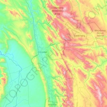
Name: Cederberg Ward 1 topographic map, elevation, terrain.
Average elevation: 2,264 ft
Minimum elevation: 177 ft
Maximum elevation: 6,726 ft
Make a donation
Gear up for your next adventure:
As an Amazon Associate, this site earns from qualifying purchases at no extra cost to you.
Other topographic maps
Click on a map to view its topography, its elevation and its terrain.
Clanwilliam
South Africa > Western Cape > West Coast District Municipality > Cederberg Local Municipality
Clanwilliam is situated at an elevation of 100 metres (330 ft), between the western slopes of the Cederberg mountains and the east bank of the Olifants River, which is impounded there by the Clanwilliam Dam. It is located just off the N7 national road, which runs from Cape Town to the Namibian border, and on…
Average elevation: 531 ft
Citrusdal
South Africa > Western Cape > West Coast District Municipality > Cederberg Local Municipality
Average elevation: 840 ft
Wolfberg Arch
South Africa > Western Cape > West Coast District Municipality > Cederberg Local Municipality > Cederberg
Average elevation: 4,636 ft
Bulshoek Dam
South Africa > Western Cape > West Coast District Municipality > Cederberg Local Municipality
Average elevation: 604 ft
Make a donation
Gear up for your next adventure:
As an Amazon Associate, this site earns from qualifying purchases at no extra cost to you.
Elandsbaai
South Africa > Western Cape > West Coast District Municipality > Cederberg Local Municipality
Average elevation: 141 ft
Lambert's Bay
South Africa > Western Cape > West Coast District Municipality > Cederberg Local Municipality
Average elevation: 62 ft
Tafelberg
South Africa > Western Cape > West Coast District Municipality > Cederberg Local Municipality
Average elevation: 5,007 ft
Sneeuberg
South Africa > Western Cape > West Coast District Municipality > Cederberg Local Municipality
Average elevation: 5,059 ft
Make a donation
Gear up for your next adventure:
As an Amazon Associate, this site earns from qualifying purchases at no extra cost to you.
Krom
South Africa > Western Cape > West Coast District Municipality > Cederberg Local Municipality
Average elevation: 2,854 ft
Clanwilliam
South Africa > Western Cape > West Coast District Municipality > Cederberg Local Municipality
Clanwilliam is situated at an elevation of 100 metres (330 ft), between the western slopes of the Cederberg mountains and the east bank of the Olifants River, which is impounded there by the Clanwilliam Dam. It lies just off the N7 national road, which runs from Cape Town to the Namibian border, and on the…
Average elevation: 531 ft
Graafwater
South Africa > Western Cape > West Coast District Municipality > Cederberg Local Municipality
Average elevation: 646 ft