Geolocate

Ingram topographic map

Click on the map to display elevation.

About this map

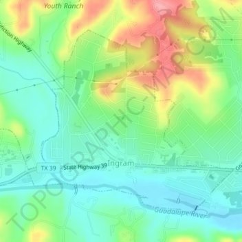
Name: Ingram topographic map, elevation, terrain.

Location: Ingram, Kerr County, Texas, United States (30.06775 -99.25512 30.09041 -99.22043)

Average elevation: 1,781 ft

Minimum elevation: 1,660 ft

Maximum elevation: 2,001 ft

Kerr County trails, hiking, mountain biking, running and outdoor activities

Other topographic maps

Click on a map to view its topography, its elevation and its terrain.

Mountain Home

United States > Texas > Kerr County

Average elevation: 2,011 ft

Camp Verde

United States > Texas > Kerr County

Average elevation: 1,726 ft

Hunt

United States > Texas > Kerr County

Average elevation: 1,877 ft

Guadalupe River

United States > Texas > Kerr County > Kerrville

Average elevation: 1,673 ft

Guadalupe River

United States > Texas > Kerr County > Kerrville

Average elevation: 1,673 ft

Center Point

United States > Texas > Kerr County

Average elevation: 1,545 ft

Guadalupe River

United States > Texas > Kerr County > Kerrville

Average elevation: 1,673 ft

Hunt

United States > Texas > Kerr County

Average elevation: 1,877 ft

Hunt

United States > Texas > Kerr County

Average elevation: 1,877 ft

Guadalupe River

United States > Texas > Kerr County > Kerrville

Average elevation: 1,673 ft

Gear up for your next adventure:

🌲Outdoor Survival Books - Best books on survival skills
🛠️Outdoor Gear Repair Kit - Essential tools to fix gear on the trail
🧭Orienteering Set - Complete compass and map reading kit
📡GPS Antenna Upgrade - Enhance GPS reception in remote terrain
Camping Coffee Makers - Enjoy premium coffee at the summit or campsite

As an Amazon Associate, this site earns from qualifying purchases at no extra cost to you.