
Akupu topographic map
Click on the map to display elevation.
About this map
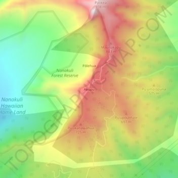
Name: Akupu topographic map, elevation, terrain.
Location: Akupu, Kapolei, Honolulu County, Hawaii, United States (21.37417 -158.12306 21.41417 -158.08306)
Average elevation: 1,598 ft
Minimum elevation: 302 ft
Maximum elevation: 3,061 ft
Honolulu County trails, hiking, mountain biking, running and outdoor activities
Other topographic maps
Click on a map to view its topography, its elevation and its terrain.
Maili
United States > Hawaii > Honolulu County > Kapolei
Māʻili (Hawaiian pronunciation: [maːˈʔili]) is a census-designated place (CDP) in the Waiʻanae District on the island of Oʻahu, City & County of Honolulu, Hawaiʻi, United States. In Hawaiian, māʻili means "pebbly", referring to rounded stones at the shore. Māʻili is located along Farrington Highway…
Average elevation: 20 ft