
Maili topographic map
Click on the map to display elevation.
Maili
Māʻili (Hawaiian pronunciation: [maːˈʔili]) is a census-designated place (CDP) in the Waiʻanae District on the island of Oʻahu, City & County of Honolulu, Hawaiʻi, United States. In Hawaiian, māʻili means "pebbly", referring to rounded stones at the shore. Māʻili is located along Farrington Highway on Oʻahu's Leeward Coast, between Māʻili Beach Park to the west and Lualualei Valley to the east. It is located 1.4 miles south of the town of Waianae, separated by the Māʻiliʻili Stream, and 1.5 miles north of Nanakuli. As of the 2020 census, the town population was 11,535. Māʻili has one 7-Eleven, a gas station, and a few residential developments. The town is also home to several dairy farms and vegetable plots. Two tall, red antennae near the mouth of the Lualualei Valley are parts of the Navcom Radio Transmitting Facility, and were the tallest man-made structures in the Western Hemisphere at 1,503 feet when they were built in 1972. The town has an elevation of 20 feet (6.1 m).
About this map
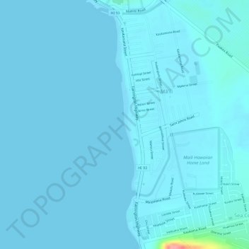
Name: Maili topographic map, elevation, terrain.
Average elevation: 20 ft
Minimum elevation: 0 ft
Maximum elevation: 351 ft
Honolulu County trails, hiking, mountain biking, running and outdoor activities
Other topographic maps
Click on a map to view its topography, its elevation and its terrain.