
Chestnut Mountain topographic map
Click on the map to display elevation.
About this map
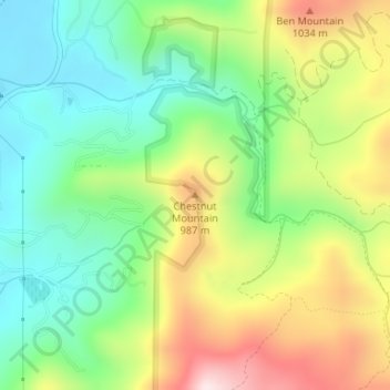
Name: Chestnut Mountain topographic map, elevation, terrain.
Average elevation: 2,736 ft
Minimum elevation: 2,106 ft
Maximum elevation: 3,720 ft
Rabun County trails, hiking, mountain biking, running and outdoor activities
Other topographic maps
Click on a map to view its topography, its elevation and its terrain.
Rabun Gap Nacoochee School Lake Dam
United States > Georgia > Rabun County
Average elevation: 2,201 ft
Tallulah Gorge State Park
United States > Georgia > Rabun County > Tallulah Falls
Average elevation: 1,427 ft
Black Rock Mountain State Park
United States > Georgia > Rabun County > Mountain City
Average elevation: 2,733 ft